Metal Print > Europe > United Kingdom > England > Somerset > Bath
Metal Print : Old Map of Bath 1851 by John Tallis


Metal Prints From MapSeeker
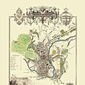
Old Map of Bath 1851 by John Tallis
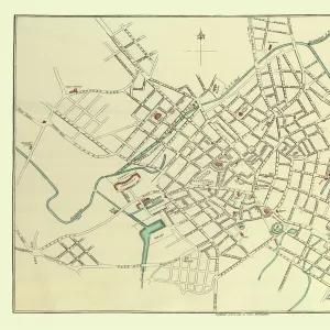
This is a splendid Victorian map by John Tallis 1851 of the historic Spa City of Bath in North East Somerset nestled between a bend on the River Avon. The great Victorian parks and famous gardens surround Bath. The plan displays three splendid illustrations. These illustrations are Royal Crescent, Abbey Church and St Michaels Church
Welcome to the Mapseeker Image library and enter an historic gateway to one of the largest on-line collections of Historic Maps, Nostalgic Views, Vista's and Panorama's from a World gone by.
Media ID 20347866
Historic Map John Tallis John Tallis Map Old Town Plan Tallis Map Bath City
16"x24" (61x41cm) Metal Print
Step back in time with our exquisite Metal Print of the Old Map of Bath 1851 by John Tallis from MapSeeker. This captivating Victorian map transports you to the historic Spa City of Bath, nestled between a bend on the River Avon in North East Somerset. The intricate details of the map are brought to life on high-quality metal, creating a stunning and unique piece of wall art that is sure to be a conversation starter in any room. Add a touch of history and elegance to your decor with this beautiful representation of Bath in its past glory.
Made with durable metal and luxurious printing techniques, our metal photo prints go beyond traditional canvases, adding a cool, modern touch to your space. Wall mount on back. Eco-friendly 100% post-consumer recycled ChromaLuxe aluminum surface. The thickness of the print is 0.045". Featuring a Scratch-resistant surface and Rounded corners. Backing hangers are attached to the back of the print and float the print 1/2-inch off the wall when hung, the choice of hanger may vary depending on size and International orders will come with Float Mount hangers only. Finished with a brilliant white high gloss surface for unsurpassed detail and vibrance. Printed using Dye-Sublimation and for best care we recommend a non-ammonia glass cleaner, water, or isopropyl (rubbing) alcohol to prevent harming the print surface. We recommend using a clean, lint-free cloth to wipe off the print. The ultra-hard surface is scratch-resistant, waterproof and weatherproof. Avoid direct sunlight exposure.
Made with durable metal and luxurious printing techniques, metal prints bring images to life and add a modern touch to any space
Estimated Product Size is 61.5cm x 41.2cm (24.2" x 16.2")
These are individually made so all sizes are approximate
Artwork printed orientated as per the preview above, with landscape (horizontal) orientation to match the source image.
FEATURES IN THESE COLLECTIONS
> MapSeeker
> British Town And City Plans
> English & Welsh PORTFOLIO
> Arts
> Artists
> T
> John Tallis
> Europe
> United Kingdom
> England
> Avon
> Europe
> United Kingdom
> England
> Somerset
> Bath
> Europe
> United Kingdom
> England
> Somerset
> Related Images
EDITORS COMMENTS
This stunning Victorian map, created by John Tallis in 1851, offers a captivating glimpse into the historic Spa City of Bath. Nestled gracefully between a bend on the picturesque River Avon, Bath is surrounded by magnificent Victorian parks and world-renowned gardens. This meticulously detailed plan showcases three remarkable illustrations that truly capture the essence of this enchanting city. The first illustration portrays the iconic Royal Crescent, an architectural masterpiece consisting of 30 terraced houses arranged in a sweeping crescent shape. Its elegant Georgian design has made it one of Bath's most recognizable landmarks and a symbol of its rich history. The second illustration features the Abbey Church, an awe-inspiring Gothic structure that dominates Bath's skyline. With its intricate stonework and towering spires, this ancient place of worship holds great significance as one of England's finest examples of ecclesiastical architecture. Lastly, we are treated to a depiction of St Michaels Church, another notable religious site within Bath. This charming parish church boasts a blend of architectural styles from different periods and serves as a testament to the city's diverse cultural heritage. As we explore this old map with its delicate engravings and meticulous attention to detail, we are transported back in time to experience the grandeur and beauty that defined Victorian-era Bath. It serves as both an invaluable historical document and a work of art that captures the essence and charm of this remarkable city for generations to come.
MADE IN THE USA
Safe Shipping with 30 Day Money Back Guarantee
FREE PERSONALISATION*
We are proud to offer a range of customisation features including Personalised Captions, Color Filters and Picture Zoom Tools
SECURE PAYMENTS
We happily accept a wide range of payment options so you can pay for the things you need in the way that is most convenient for you
* Options may vary by product and licensing agreement. Zoomed Pictures can be adjusted in the Basket.