Metal Print > Arts > Artists > W > Frederick de Wit
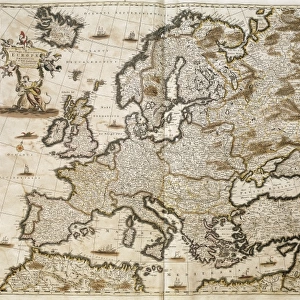
Metal Print : Map Nova et accurate divisa regna et regiones praecipuas Europae descriptio


![]()
Metal Prints From Liszt Collection
Map Nova et accurate divisa regna et regiones praecipuas Europae descriptio
Map, Nova et accurate divisa in regna et regiones praecipuas Europae descriptio per F. de Witt Amstelodami, Frederick de Wit (1630-1706), Copperplate print
Liszt Collection of nineteenth-century engravings and images to browse and enjoy
Media ID 19584853
© Artokoloro
1630 1706 Copperplate Print Frederick De Wit
16"x20" (51x41cm) Metal Print
Discover the captivating allure of history with our Media Storehouse Metal Prints. This exquisite piece showcases the detailed and intricately designed map, "Nova et accurate divisa in regna et regiones praecipuas Europae descriptio," from the esteemed Liszt Collection. Dating back to the 17th century, this copperplate print by Frederick de Wit offers a captivating glimpse into the geography of Europe during that era. The vibrant colors and sharp details are beautifully preserved in our high-quality metal print, making it a stunning addition to any home or office. Relive the rich history of Europe with this timeless masterpiece.
Made with durable metal and luxurious printing techniques, our metal photo prints go beyond traditional canvases, adding a cool, modern touch to your space. Wall mount on back. Eco-friendly 100% post-consumer recycled ChromaLuxe aluminum surface. The thickness of the print is 0.045". Featuring a Scratch-resistant surface and Rounded corners. Backing hangers are attached to the back of the print and float the print 1/2-inch off the wall when hung, the choice of hanger may vary depending on size and International orders will come with Float Mount hangers only. Finished with a brilliant white high gloss surface for unsurpassed detail and vibrance. Printed using Dye-Sublimation and for best care we recommend a non-ammonia glass cleaner, water, or isopropyl (rubbing) alcohol to prevent harming the print surface. We recommend using a clean, lint-free cloth to wipe off the print. The ultra-hard surface is scratch-resistant, waterproof and weatherproof. Avoid direct sunlight exposure.
Made with durable metal and luxurious printing techniques, metal prints bring images to life and add a modern touch to any space
Estimated Image Size (if not cropped) is 50.8cm x 40.6cm (20" x 16")
Estimated Product Size is 51.4cm x 41.2cm (20.2" x 16.2")
These are individually made so all sizes are approximate
Artwork printed orientated as per the preview above, with landscape (horizontal) orientation to match the source image.
FEATURES IN THESE COLLECTIONS
> Arts
> Artists
> W
> Frederick de Wit
> Maps and Charts
> Related Images
EDITORS COMMENTS
This print showcases the remarkable "Map Nova et accurate divisa regna et regiones praecipuas Europae descriptio" by Frederick de Wit, a renowned cartographer from the 17th century. With its intricate details and exquisite craftsmanship, this copperplate print is a true testament to De Wit's skill and artistry. The map itself provides an extraordinary depiction of Europe, meticulously divided into kingdoms and principal regions. Every line, curve, and symbol on this masterpiece tells a story of exploration and discovery during a time when maps were not just navigational tools but works of art. Frederick de Wit's contribution to cartography cannot be overstated. His maps were highly sought after for their accuracy and aesthetic appeal. This particular print captures the essence of his genius as it transports us back in time to an era where geography was still being explored. As we gaze upon this stunning piece, we can't help but marvel at the level of detail that went into creating such an intricate map. The delicate lines tracing coastlines, rivers meandering through vast landscapes, and cities marked with tiny dots all come together to form a visual feast for our eyes. Whether you are a history enthusiast or simply appreciate fine art, this print allows you to own a piece of European cartographic history. It serves as both a reminder of how far we have come in understanding our world and an homage to the brilliance of Frederick de Wit's work.
MADE IN THE USA
Safe Shipping with 30 Day Money Back Guarantee
FREE PERSONALISATION*
We are proud to offer a range of customisation features including Personalised Captions, Color Filters and Picture Zoom Tools
SECURE PAYMENTS
We happily accept a wide range of payment options so you can pay for the things you need in the way that is most convenient for you
* Options may vary by product and licensing agreement. Zoomed Pictures can be adjusted in the Basket.