Metal Print > Maps and Charts > Related Images
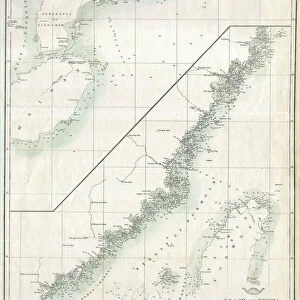
Metal Print : Map Magni ducatus Lithuaniae divisa tam palatinatus quam


![]()
Metal Prints from Liszt Collection
Map Magni ducatus Lithuaniae divisa tam palatinatus quam
Map, Magni ducatus Lithuaniae divisa tam in palatinatus quam in subiacentes castellanias authore per R. & J. Ottens Amst, Reinier Ottens (1698-1750), Josua Ottens (1704-1765), Copperplate print
Liszt Collection of nineteenth-century engravings and images to browse and enjoy
Media ID 19585001
© Artokoloro
1698 1750 1704 1765 Copperplate Print Reinier Ottens
16"x20" (51x41cm) Metal Print
Discover historical elegance with our Media Storehouse Metal Prints featuring the intricately detailed Map of the Grand Duchy of Lithuania, divided into palatinates and subordinate castellanies, from the esteemed Liszt Collection. This exquisite copperplate print, produced by the renowned Ottens brothers in Amsterdam during the late 18th century, showcases the rich history and complexity of the Lithuanian territories. Bring this captivating piece of history into your home or office and elevate your decor with a stunning, long-lasting metal print. Each print is carefully crafted using premium metal sheets and high-definition printing technology, ensuring a vibrant and durable display that will captivate and inspire.
Made with durable metal and luxurious printing techniques, our metal photo prints go beyond traditional canvases, adding a cool, modern touch to your space. Wall mount on back. Eco-friendly 100% post-consumer recycled ChromaLuxe aluminum surface. The thickness of the print is 0.045". Featuring a Scratch-resistant surface and Rounded corners. Backing hangers are attached to the back of the print and float the print 1/2-inch off the wall when hung, the choice of hanger may vary depending on size and International orders will come with Float Mount hangers only. Finished with a brilliant white high gloss surface for unsurpassed detail and vibrance. Printed using Dye-Sublimation and for best care we recommend a non-ammonia glass cleaner, water, or isopropyl (rubbing) alcohol to prevent harming the print surface. We recommend using a clean, lint-free cloth to wipe off the print. The ultra-hard surface is scratch-resistant, waterproof and weatherproof. Avoid direct sunlight exposure.
Made with durable metal and luxurious printing techniques, metal prints bring images to life and add a modern touch to any space
Estimated Image Size (if not cropped) is 50.8cm x 40.6cm (20" x 16")
Estimated Product Size is 51.4cm x 41.2cm (20.2" x 16.2")
These are individually made so all sizes are approximate
Artwork printed orientated as per the preview above, with landscape (horizontal) orientation to match the source image.
EDITORS COMMENTS
This print showcases a remarkable map titled "Map Magni ducatus Lithuaniae divisa tam palatinatus quam". Created by the talented duo Reinier and Josua Ottens in Amsterdam, this copperplate print is a true masterpiece. The intricate details and precision of this map are truly awe-inspiring. The map beautifully depicts the grand duchy of Lithuania, divided into both palatinates and subjugated castellanies. Its rich colors bring to life the vast territories that once belonged to this historic region. Every stroke on this copperplate print tells a story, revealing the immense knowledge and skill possessed by its creators. Reinier Ottens (1698-1750) and Josua Ottens (1704-1765) have left an indelible mark on cartography with their exceptional craftsmanship. This print allows us to appreciate their dedication to accuracy and artistry even centuries later. As we gaze upon this magnificent piece, we can't help but be transported back in time, imagining the explorers who relied on maps like these for navigation or historians who sought insights into past civilizations. It serves as a testament to human curiosity and our constant quest for knowledge about our world's history. Whether you are an avid collector or simply fascinated by historical artifacts, this print is sure to captivate your imagination while adding a touch of elegance to any space it graces.
MADE IN THE USA
Safe Shipping with 30 Day Money Back Guarantee
FREE PERSONALISATION*
We are proud to offer a range of customisation features including Personalised Captions, Color Filters and Picture Zoom Tools
SECURE PAYMENTS
We happily accept a wide range of payment options so you can pay for the things you need in the way that is most convenient for you
* Options may vary by product and licensing agreement. Zoomed Pictures can be adjusted in the Cart.