Metal Print > Animals > Mammals > Didelphidae > Formosa
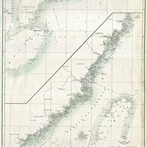
Metal Print : Political map of the Japanese Empire, early 20th century


![]()
Metal Prints from Heritage Images
Political map of the Japanese Empire, early 20th century
Political map of the Japanese Empire, early 20th century. Korea was under Japanese rule from 1910-1945. Japanese forces invaded and occupied Sakhalin during the Russo-Japanese War in 1905. Taiwan was ceded in full sovereignty to the Empire of Japan by the Treaty of Shimonoseki during the First Sino-Japanese War (1894-1895). Plate 65 from The Times Atlas
Heritage Images features heritage image collections
Media ID 15464820
© The Print Collector / Heritage-Images
Cartography Formosa Korea Map Making Pacific Ocean Taiwan Japanese Empire Sakhalin
16"x20" (51x41cm) Metal Print
Step back in time with our stunning Metal Print of the Japanese Empire Political Map from Heritage Images. This captivating piece of history depicts the extent of the Japanese Empire during the early 20th century, a period marked by significant expansion and territorial acquisitions. Korea, which was under Japanese rule from 1910-1945, and Sakhalin, occupied during the Russo-Japanese War in 1905, are clearly outlined in this intricately detailed map. Bring history into your home or office with our high-quality Metal Print, which not only preserves the intricacies of the map but also adds a modern and contemporary touch with its sleek metal finish. This unique and thought-provoking piece is sure to make a statement and spark conversation.
Made with durable metal and luxurious printing techniques, our metal photo prints go beyond traditional canvases, adding a cool, modern touch to your space. Wall mount on back. Eco-friendly 100% post-consumer recycled ChromaLuxe aluminum surface. The thickness of the print is 0.045". Featuring a Scratch-resistant surface and Rounded corners. Backing hangers are attached to the back of the print and float the print 1/2-inch off the wall when hung, the choice of hanger may vary depending on size and International orders will come with Float Mount hangers only. Finished with a brilliant white high gloss surface for unsurpassed detail and vibrance. Printed using Dye-Sublimation and for best care we recommend a non-ammonia glass cleaner, water, or isopropyl (rubbing) alcohol to prevent harming the print surface. We recommend using a clean, lint-free cloth to wipe off the print. The ultra-hard surface is scratch-resistant, waterproof and weatherproof. Avoid direct sunlight exposure.
Made with durable metal and luxurious printing techniques, metal prints bring images to life and add a modern touch to any space
Estimated Image Size (if not cropped) is 40.6cm x 50.8cm (16" x 20")
Estimated Product Size is 41.2cm x 51.4cm (16.2" x 20.2")
These are individually made so all sizes are approximate
Artwork printed orientated as per the preview above, with portrait (vertical) orientation to match the source image.
FEATURES IN THESE COLLECTIONS
> Animals
> Mammals
> Didelphidae
> Formosa
> Arts
> Artists
> O
> Oceanic Oceanic
> Asia
> Japan
> Related Images
> Asia
> Taiwan
> Related Images
> Europe
> Russia
> Related Images
EDITORS COMMENTS
This print showcases a political map of the Japanese Empire during the early 20th century. The intricate details and vibrant colors bring to life an era marked by significant geopolitical changes. Notably, this map highlights Japan's control over Korea from 1910 to 1945, a period characterized by intense colonization and cultural assimilation. The Russo-Japanese War in 1905 is also depicted here, as Japanese forces invaded and occupied Sakhalin, a Russian territory at the time. This conflict further solidified Japan's expanding influence in the Pacific region. Additionally, the Treaty of Shimonoseki following the First Sino-Japanese War granted full sovereignty of Taiwan to the Empire of Japan. This territorial acquisition played a crucial role in shaping Japan's imperial ambitions and its growing presence on both sides of the Pacific Ocean. Plate 65 from The Times Atlas serves as a testament to cartography's power in capturing historical events and geographical transformations. It allows us to delve into past narratives while appreciating how maps have shaped our understanding of countries, empires, and their ever-evolving borders. This remarkable print not only offers insight into Japan's expansionist policies but also invites contemplation on imperialism's lasting impact on nations like Korea and Taiwan. As we study this image with curiosity and reverence for history, let us remember that it represents more than just lines on paper – it symbolizes complex stories etched onto landscapes across time.
MADE IN THE USA
Safe Shipping with 30 Day Money Back Guarantee
FREE PERSONALISATION*
We are proud to offer a range of customisation features including Personalised Captions, Color Filters and Picture Zoom Tools
SECURE PAYMENTS
We happily accept a wide range of payment options so you can pay for the things you need in the way that is most convenient for you
* Options may vary by product and licensing agreement. Zoomed Pictures can be adjusted in the Cart.