Metal Print > Europe > United Kingdom > Scotland > Edinburgh > Edinburgh
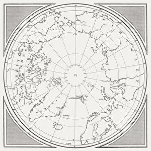
Metal Print : North Polar Chart, 1902. Creator: Unknown


![]()
Metal Prints From Heritage Images
North Polar Chart, 1902. Creator: Unknown
North Polar Chart, 1902. Showing the Arctic Circle. From The Century Atlas of the World. [John Walker & Co, Ltd. London, 1902]
Heritage Images features heritage image collections
Media ID 15512830
© The Print Collector / Heritage-Images
Arctic Circle Arctic Ocean Canada Edinburgh Geographical Institute Greenland North Pole Ocean
16"x20" (51x41cm) Metal Print
Discover the mysteries of the Arctic with our Media Storehouse Metal Print featuring a historic North Polar Chart from 1902. This captivating vintage map, sourced from Heritage Images, showcases the Arctic Circle in intricate detail. Bring the enigmatic allure of the North Pole into your home or office with this high-quality Metal Print. The vibrant colors and sharp lines of the map are beautifully preserved, making it a stunning addition to any decor. Unknown creator, The Century Atlas of the World, John Walker & Co, Ltd. London, 1902. Experience the thrill of exploration with a piece of history at your fingertips.
Made with durable metal and luxurious printing techniques, our metal photo prints go beyond traditional canvases, adding a cool, modern touch to your space. Wall mount on back. Eco-friendly 100% post-consumer recycled ChromaLuxe aluminum surface. The thickness of the print is 0.045". Featuring a Scratch-resistant surface and Rounded corners. Backing hangers are attached to the back of the print and float the print 1/2-inch off the wall when hung, the choice of hanger may vary depending on size and International orders will come with Float Mount hangers only. Finished with a brilliant white high gloss surface for unsurpassed detail and vibrance. Printed using Dye-Sublimation and for best care we recommend a non-ammonia glass cleaner, water, or isopropyl (rubbing) alcohol to prevent harming the print surface. We recommend using a clean, lint-free cloth to wipe off the print. The ultra-hard surface is scratch-resistant, waterproof and weatherproof. Avoid direct sunlight exposure.
Made with durable metal and luxurious printing techniques, metal prints bring images to life and add a modern touch to any space
Estimated Image Size (if not cropped) is 50.8cm x 40.6cm (20" x 16")
Estimated Product Size is 51.4cm x 41.2cm (20.2" x 16.2")
These are individually made so all sizes are approximate
Artwork printed orientated as per the preview above, with landscape (horizontal) orientation to match the source image.
FEATURES IN THESE COLLECTIONS
> Arts
> Artists
> O
> Oceanic Oceanic
> Europe
> United Kingdom
> Scotland
> Edinburgh
> Edinburgh
> Europe
> United Kingdom
> Scotland
> Lothian
> Edinburgh
> Maps and Charts
> Related Images
> Maps and Charts
> World
> North America
> Canada
> Maps
> North America
> Canada
> Related Images
EDITORS COMMENTS
This print showcases the North Polar Chart from 1902, a remarkable creation by an unknown artist. The chart beautifully depicts the Arctic Circle, offering a glimpse into the vast and icy expanse of the Arctic Ocean. This historical artifact was featured in The Century Atlas of the World, published by John Walker & Co in London during that era. The vibrant colors used in this print bring to life various countries and regions surrounding the North Pole. From Canada to Russia, each country is clearly marked on this map, allowing viewers to appreciate their geographical locations within this remote part of our planet. Notably, Greenland stands out with its distinct shape and position on this chart. Created by Edinburgh Geographical Institute, this map serves as both an educational tool and a testament to human curiosity about unexplored territories. It offers valuable insights into early 20th-century geography while igniting our imagination about what lies beyond these icy waters. Preserved meticulously by The Print Collector - not for commercial use - this photograph captures a moment frozen in time. As we gaze upon it today, we are reminded of humanity's relentless pursuit of knowledge and exploration throughout history.
MADE IN THE USA
Safe Shipping with 30 Day Money Back Guarantee
FREE PERSONALISATION*
We are proud to offer a range of customisation features including Personalised Captions, Color Filters and Picture Zoom Tools
SECURE PAYMENTS
We happily accept a wide range of payment options so you can pay for the things you need in the way that is most convenient for you
* Options may vary by product and licensing agreement. Zoomed Pictures can be adjusted in the Basket.