Metal Print > Europe > France > Paris > Maps
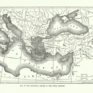
Metal Print : Map of the Byzantine Empire in the Ninth Century, 1890. Creator: Unknown


![]()
Metal Prints from Heritage Images
Map of the Byzantine Empire in the Ninth Century, 1890. Creator: Unknown
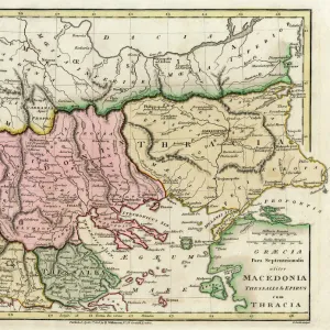
Map of the Byzantine Empire in the Ninth Century, 1890. The Byzantine Empire underwent a revival under Macedonian emperors from Basil I (867-886) in late 9th, 10th, and early 11th centuries. From " Cassells Illustrated Universal History, Vol. III - The Middle Ages", by Edmund Ollier. [Cassell and Company, Limited, London, Paris and Melbourne, 1890. ]
Heritage Images features heritage image collections
Media ID 19127365
© The Print Collector/Heritage Images
9th Century Basil Black Sea Byzantine Byzantium Cassells Cassells Illustrated Universal History Co Cassell Control Edmund Edmund Ollier Macedonia Macedonian Middle Eastern Ollier Ollier Edmund Territorial Territory Cassell And Company Ltd
16"x24" (61x41cm) Metal Print
Step back in time with our exquisite Metal Print of the Byzantine Empire Map from the ninth century, 1890. This intricately detailed and captivating image, sourced from Heritage Images, showcases the Byzantine Empire during its revival under the Macedonian emperors Basil I (867-886). Bring history to life in your home or office with this unique and stylish decor piece. The high-quality metal print is not only an impressive work of art but also a conversation starter. Order now and travel through time with every glance.
Made with durable metal and luxurious printing techniques, our metal photo prints go beyond traditional canvases, adding a cool, modern touch to your space. Wall mount on back. Eco-friendly 100% post-consumer recycled ChromaLuxe aluminum surface. The thickness of the print is 0.045". Featuring a Scratch-resistant surface and Rounded corners. Backing hangers are attached to the back of the print and float the print 1/2-inch off the wall when hung, the choice of hanger may vary depending on size and International orders will come with Float Mount hangers only. Finished with a brilliant white high gloss surface for unsurpassed detail and vibrance. Printed using Dye-Sublimation and for best care we recommend a non-ammonia glass cleaner, water, or isopropyl (rubbing) alcohol to prevent harming the print surface. We recommend using a clean, lint-free cloth to wipe off the print. The ultra-hard surface is scratch-resistant, waterproof and weatherproof. Avoid direct sunlight exposure.
Made with durable metal and luxurious printing techniques, metal prints bring images to life and add a modern touch to any space
Estimated Product Size is 61.5cm x 41.2cm (24.2" x 16.2")
These are individually made so all sizes are approximate
Artwork printed orientated as per the preview above, with landscape (horizontal) orientation to match the source image.
FEATURES IN THESE COLLECTIONS
> Arts
> Art Movements
> Medieval Art
> Arts
> Literature
> Europe
> France
> Paris
> Maps
> Europe
> Macedonia
> Posters
> Europe
> Macedonia
> Related Images
> Maps and Charts
> Early Maps
> Maps and Charts
> North Macedonia
> Maps and Charts
> Related Images
EDITORS COMMENTS
This print showcases a remarkable piece of history - the Map of the Byzantine Empire in the Ninth Century, created in 1890 by an unknown artist. The Byzantine Empire experienced a renaissance during the reign of Macedonian emperors, particularly under Basil I from 867 to 886. This map beautifully illustrates their territorial control and influence over vast regions. From "Cassells Illustrated Universal History, Vol. III - The Middle Ages" by Edmund Ollier, this antique engraving offers a close-up view of the empire's geographical features and boundaries. It takes us back to a time when literature, art, and architecture flourished under Byzantium's rule. The monochrome aesthetic adds an air of mystery and nostalgia to this historical artifact. As we examine every detail on this intricate map, we can't help but marvel at its significance in understanding medieval times. While the creator remains anonymous, their work stands as a testament to human curiosity about our past. This print serves as both an educational tool for those interested in geography and history enthusiasts alike. Whether displayed in libraries or private collections, this photograph invites viewers into an era long gone but not forgotten – where empires rose and fell against the backdrop of political intrigue and cultural exchange across Europe and Asia Minor.
MADE IN THE USA
Safe Shipping with 30 Day Money Back Guarantee
FREE PERSONALISATION*
We are proud to offer a range of customisation features including Personalised Captions, Color Filters and Picture Zoom Tools
SECURE PAYMENTS
We happily accept a wide range of payment options so you can pay for the things you need in the way that is most convenient for you
* Options may vary by product and licensing agreement. Zoomed Pictures can be adjusted in the Cart.