Metal Print > Arts > Artists > O > Abraham Ortelius
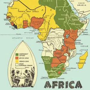
Metal Print : MAP OF AFRICA from the 1595 edition of Abraham Ortelius atlas Theatrum Orbis Terrarum


![]()
Metal Prints From Granger
MAP OF AFRICA from the 1595 edition of Abraham Ortelius atlas Theatrum Orbis Terrarum
MAP OF AFRICA from the 1595 edition of Abraham Ortelius atlas " Theatrum Orbis Terrarum."
Granger holds millions of images spanning more than 25,000 years of world history, from before the Stone Age to the dawn of the Space Age
Media ID 6617627
1595 Abraham Africa African Ortelius Theatrum Orbis Terrarum
16"x20" (51x41cm) Metal Print
Step back in time with our exquisite Metal Prints featuring the iconic Map of Africa from the 1595 edition of Abraham Ortelius's Theatrum Orbis Terrarum. This intricately detailed map, sourced from The Granger Collection at Granger Art on Demand, showcases the fascinating cartography of the time. Each Metal Print is meticulously crafted, bringing the historical accuracy and vintage charm of this precious artifact to your home or office. Experience the rich history of exploration and discovery with this stunning piece of decor. Order your Metal Print today and make a statement with timeless elegance.
Made with durable metal and luxurious printing techniques, our metal photo prints go beyond traditional canvases, adding a cool, modern touch to your space. Wall mount on back. Eco-friendly 100% post-consumer recycled ChromaLuxe aluminum surface. The thickness of the print is 0.045". Featuring a Scratch-resistant surface and Rounded corners. Backing hangers are attached to the back of the print and float the print 1/2-inch off the wall when hung, the choice of hanger may vary depending on size and International orders will come with Float Mount hangers only. Finished with a brilliant white high gloss surface for unsurpassed detail and vibrance. Printed using Dye-Sublimation and for best care we recommend a non-ammonia glass cleaner, water, or isopropyl (rubbing) alcohol to prevent harming the print surface. We recommend using a clean, lint-free cloth to wipe off the print. The ultra-hard surface is scratch-resistant, waterproof and weatherproof. Avoid direct sunlight exposure.
Made with durable metal and luxurious printing techniques, metal prints bring images to life and add a modern touch to any space
Estimated Image Size (if not cropped) is 50.8cm x 40.6cm (20" x 16")
Estimated Product Size is 51.4cm x 41.2cm (20.2" x 16.2")
These are individually made so all sizes are approximate
Artwork printed orientated as per the preview above, with landscape (horizontal) orientation to match the source image.
FEATURES IN THESE COLLECTIONS
> Granger Art on Demand
> Maps
> Arts
> Art Movements
> Renaissance Art
> Arts
> Artists
> O
> Abraham Ortelius
> Arts
> Landscape paintings
> Waterfall and river artworks
> River artworks
> Maps and Charts
> Abraham Ortelius
> Maps and Charts
> Related Images
EDITORS COMMENTS
This print showcases a remarkable piece of history - the Map of Africa from the 1595 edition of Abraham Ortelius' renowned atlas, Theatrum Orbis Terrarum. A true gem from the Renaissance era, this map is a testament to Ortelius' pioneering cartographic skills and his dedication to accurately representing the world. The intricate details on this map transport us back in time, allowing us to explore Africa as it was perceived over four centuries ago. From its majestic rivers snaking through vast landscapes to its diverse regions marked with precision, every element tells a story of exploration and discovery. Ortelius' mastery shines through in his depiction of African geography, showcasing his deep understanding of the continent's topography. This print not only serves as an educational tool but also as a work of art that captures the essence and beauty of Africa during this period. As we gaze upon this historical artifact, we are reminded that maps have always been more than just navigational tools; they are windows into different eras and cultures. The Granger Collection has preserved this invaluable piece for us to appreciate and learn from, bridging the gap between past and present. Whether you're an avid historian or simply fascinated by African heritage, this print offers a glimpse into our collective human journey across time. Let it inspire you to delve deeper into Africa's rich history while appreciating Ortelius' contribution to our understanding of our world.
MADE IN THE USA
Safe Shipping with 30 Day Money Back Guarantee
FREE PERSONALISATION*
We are proud to offer a range of customisation features including Personalised Captions, Color Filters and Picture Zoom Tools
SECURE PAYMENTS
We happily accept a wide range of payment options so you can pay for the things you need in the way that is most convenient for you
* Options may vary by product and licensing agreement. Zoomed Pictures can be adjusted in the Basket.