Metal Print > Africa > Central African Republic > Maps
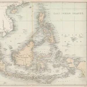
Metal Print : Congo map, central Africa from 1895


![]()
Metal Prints from Fine Art Storehouse
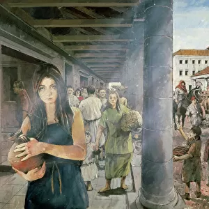
Congo map, central Africa from 1895
Illustration of a Congo map, central Africa from 1895
Unleash your creativity and transform your space into a visual masterpiece!
Nastasic
Media ID 13750425
© This content is subject to copyright
1890 1899 1895 Atlas Mythological Figure Central Africa Democratic Republic Of The Congo Guinea Morocco Paper Sahara Desert Serbia World Map Equatorial Guinea Republic Of The Congo
16"x20" (51x41cm) Metal Print
Step back in time with our stunning Metal Print of the Congo Map from 1895 by Nastasic, available at Media Storehouse's Fine Art Storehouse. This captivating piece of historical cartography transports you to a pivotal moment in African history. The intricate details of the map are brought to life through our premium metal printing process, ensuring vibrant colors and exceptional clarity. Display this beautiful and educational work of art in your home or office to ignite conversations and inspire curiosity. Experience history in a whole new way with Media Storehouse's Metal Prints.
Made with durable metal and luxurious printing techniques, our metal photo prints go beyond traditional canvases, adding a cool, modern touch to your space. Wall mount on back. Eco-friendly 100% post-consumer recycled ChromaLuxe aluminum surface. The thickness of the print is 0.045". Featuring a Scratch-resistant surface and Rounded corners. Backing hangers are attached to the back of the print and float the print 1/2-inch off the wall when hung, the choice of hanger may vary depending on size and International orders will come with Float Mount hangers only. Finished with a brilliant white high gloss surface for unsurpassed detail and vibrance. Printed using Dye-Sublimation and for best care we recommend a non-ammonia glass cleaner, water, or isopropyl (rubbing) alcohol to prevent harming the print surface. We recommend using a clean, lint-free cloth to wipe off the print. The ultra-hard surface is scratch-resistant, waterproof and weatherproof. Avoid direct sunlight exposure.
Made with durable metal and luxurious printing techniques, metal prints bring images to life and add a modern touch to any space
Estimated Image Size (if not cropped) is 50.8cm x 40.6cm (20" x 16")
Estimated Product Size is 51.4cm x 41.2cm (20.2" x 16.2")
These are individually made so all sizes are approximate
Artwork printed orientated as per the preview above, with landscape (horizontal) orientation to match the source image.
FEATURES IN THESE COLLECTIONS
> Fine Art Storehouse
> Map
> Historical Maps
> Fine Art Storehouse
> Travel Imagery
> Travel Destinations
> Morocco, North Africa
> Fine Art Storehouse
> Ultimate Earth Prints
> Amazing Deserts
> Africa
> Central African Republic
> Maps
> Africa
> Central African Republic
> Related Images
> Africa
> Democratic Republic of the Congo
> Related Images
> Africa
> Equatorial Guinea
> Maps
> Africa
> Equatorial Guinea
> Related Images
> Africa
> Guinea
> Related Images
> Africa
> Morocco
> Related Images
> Africa
> Related Images
EDITORS COMMENTS
This print showcases an exquisite illustration of a Congo map from 1895, offering a glimpse into the historical cartography of central Africa. The intricate details and precision engraving transport us back to a time when maps were meticulously crafted by hand. The map encompasses various countries including Serbia, the USA, Equatorial Guinea, Democratic Republic of the Congo, Republic of the Congo, Morocco, and Guinea. It also highlights significant geographical features such as the Sahara Desert. This antique piece serves as a testament to the evolution of physical geography over time. The artist's skillful use of illustration techniques brings this old-world map to life on paper. Every line and contour is delicately etched with care and expertise. As we explore this enchanting artwork, it becomes evident that it not only represents geographic accuracy but also serves as a window into history. Beyond its practical purpose as a navigational tool in its era, this map holds cultural significance too. It reminds us of how our understanding of the world has evolved throughout centuries. Nastasic's remarkable creation captures both artistry and functionality in one frame—a true masterpiece that transports us through time while igniting curiosity about our planet's past exploration and discovery.
MADE IN THE USA
Safe Shipping with 30 Day Money Back Guarantee
FREE PERSONALISATION*
We are proud to offer a range of customisation features including Personalised Captions, Color Filters and Picture Zoom Tools
SECURE PAYMENTS
We happily accept a wide range of payment options so you can pay for the things you need in the way that is most convenient for you
* Options may vary by product and licensing agreement. Zoomed Pictures can be adjusted in the Cart.