Metal Print > Fine Art Storehouse > Photo Libraries > Dorling Kindersley Prints
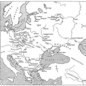
Metal Print : Digital illustration of map showing world population areas


![]()
Metal Prints From Fine Art Storehouse
Digital illustration of map showing world population areas
Unleash your creativity and transform your space into a visual masterpiece!
Dorling Kindersley
Media ID 13541113
© This content is subject to copyright
Population Western Script World Map Digitally Generated Digitally Generated Image
16"x24" (61x41cm) Metal Print
Discover the stunning visual representation of global population distribution with our Media Storehouse Metal Print featuring a digital illustration by Dorling Kindersley from Fine Art Storehouse. This captivating map showcases the intricate patterns of human settlements and population density across the world. Crafted with meticulous attention to detail, each metal print is coated with a durable, scratch-resistant finish to ensure long-lasting beauty. Elevate your home or office décor with this unique and thought-provoking piece that is sure to spark conversation and inspire curiosity.
Made with durable metal and luxurious printing techniques, our metal photo prints go beyond traditional canvases, adding a cool, modern touch to your space. Wall mount on back. Eco-friendly 100% post-consumer recycled ChromaLuxe aluminum surface. The thickness of the print is 0.045". Featuring a Scratch-resistant surface and Rounded corners. Backing hangers are attached to the back of the print and float the print 1/2-inch off the wall when hung, the choice of hanger may vary depending on size and International orders will come with Float Mount hangers only. Finished with a brilliant white high gloss surface for unsurpassed detail and vibrance. Printed using Dye-Sublimation and for best care we recommend a non-ammonia glass cleaner, water, or isopropyl (rubbing) alcohol to prevent harming the print surface. We recommend using a clean, lint-free cloth to wipe off the print. The ultra-hard surface is scratch-resistant, waterproof and weatherproof. Avoid direct sunlight exposure.
Made with durable metal and luxurious printing techniques, metal prints bring images to life and add a modern touch to any space
Estimated Product Size is 61.5cm x 41.2cm (24.2" x 16.2")
These are individually made so all sizes are approximate
Artwork printed orientated as per the preview above, with landscape (horizontal) orientation to match the source image.
EDITORS COMMENTS
This digital illustration by Dorling Kindersley depicts a map showcasing the distribution of world population areas. The artist has skillfully crafted this piece, using advanced digital techniques to create a visually striking and informative representation. The map is cut out and digitally generated, resulting in a clean and precise composition that immediately grabs attention. Its horizontal orientation allows for easy viewing, while the absence of people emphasizes the focus on population density rather than individual experiences. Set against a pristine white background, the vibrant colors of this artwork come to life. The use of Western script adds familiarity and accessibility to viewers from various cultural backgrounds. As we explore this intricate cartographic creation, it becomes evident that every detail has been meticulously considered. From densely populated regions marked with intense hues to sparsely inhabited areas depicted with softer tones, this map provides an insightful glimpse into our global demographic landscape. Dorling Kindersley's expertise shines through in their ability to seamlessly blend artistry with information. This digitally generated image serves as both an aesthetically pleasing work of art and an educational tool for understanding worldwide population patterns. Whether displayed in classrooms or homes, this print offers endless opportunities for contemplation and discussion about our interconnected world. It invites us to reflect on how human populations are distributed across continents while reminding us of the beauty found within data-driven visualizations like these.
MADE IN THE USA
Safe Shipping with 30 Day Money Back Guarantee
FREE PERSONALISATION*
We are proud to offer a range of customisation features including Personalised Captions, Color Filters and Picture Zoom Tools
SECURE PAYMENTS
We happily accept a wide range of payment options so you can pay for the things you need in the way that is most convenient for you
* Options may vary by product and licensing agreement. Zoomed Pictures can be adjusted in the Basket.