Metal Print > North America > United States of America > Maps
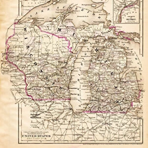
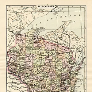
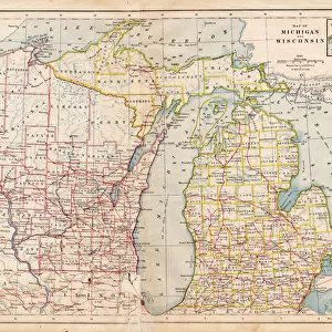
Metal Print : Wisconsin MIchigan map 1867


![]()
Metal Prints From Fine Art Storehouse
Wisconsin MIchigan map 1867
Mitchellas Modern Atlas - Published by E.H. Butler and Co - Philadelphia 1867
Unleash your creativity and transform your space into a visual masterpiece!
THEPALMER
Media ID 13609205
© This content is subject to copyright
16"x20" (51x41cm) Metal Print
Discover the rich history of the Midwest with our stunning Metal Print of the Wisconsin and Michigan Map from THEPALMER's Mitchell's Modern Atlas, published by E.H. Butler and Co in 1867. This vintage map showcases intricate detail and accurate cartography of the region during that time. Our high-quality Metal Prints are not just a decorative piece, but a conversation starter that brings history to life in your home or office space. The vibrant colors and sharp details are preserved through our premium printing process on a durable metal sheet. Add a touch of nostalgia and education to your surroundings with this unique and beautiful piece from Media Storehouse's Fine Art collection.
Made with durable metal and luxurious printing techniques, our metal photo prints go beyond traditional canvases, adding a cool, modern touch to your space. Wall mount on back. Eco-friendly 100% post-consumer recycled ChromaLuxe aluminum surface. The thickness of the print is 0.045". Featuring a Scratch-resistant surface and Rounded corners. Backing hangers are attached to the back of the print and float the print 1/2-inch off the wall when hung, the choice of hanger may vary depending on size and International orders will come with Float Mount hangers only. Finished with a brilliant white high gloss surface for unsurpassed detail and vibrance. Printed using Dye-Sublimation and for best care we recommend a non-ammonia glass cleaner, water, or isopropyl (rubbing) alcohol to prevent harming the print surface. We recommend using a clean, lint-free cloth to wipe off the print. The ultra-hard surface is scratch-resistant, waterproof and weatherproof. Avoid direct sunlight exposure.
Made with durable metal and luxurious printing techniques, metal prints bring images to life and add a modern touch to any space
Estimated Image Size (if not cropped) is 50.8cm x 40.6cm (20" x 16")
Estimated Product Size is 51.4cm x 41.2cm (20.2" x 16.2")
These are individually made so all sizes are approximate
Artwork printed orientated as per the preview above, with landscape (horizontal) orientation to match the source image.
FEATURES IN THESE COLLECTIONS
> Fine Art Storehouse
> Map
> Historical Maps
> Fine Art Storehouse
> Map
> USA Maps
> Maps and Charts
> Related Images
> North America
> United States of America
> Maps
> North America
> United States of America
> Michigan
> Related Images
> North America
> United States of America
> Wisconsin
> Related Images
EDITORS COMMENTS
This print showcases a remarkable piece of history, the "Wisconsin Michigan map 1867". Published by E. H. Butler and Co in Philadelphia during that era, this exquisite map from Mitchellas Modern Atlas takes us back to a time when cartography was an art form in itself. The level of detail and precision captured in this engraving is truly awe-inspiring. As we gaze upon this antique lithograph, we are transported to the vast landscapes of North America. The horizontal orientation allows us to fully immerse ourselves in the physical geography of these two states - Wisconsin and Michigan. Every contour and boundary line has been meticulously etched onto the surface, revealing rivers, lakes, mountains, and cities with utmost accuracy. The craftsmanship evident in this illustration is nothing short of extraordinary. Each stroke tells a story of dedication and passion for cartography as an essential tool for understanding our world. It serves as a reminder that maps were once cherished possessions that provided knowledge about distant lands before modern technology made them easily accessible at our fingertips. "The Wisconsin Michigan map 1867" by THEPALMER invites us to appreciate not only its historical significance but also the beauty found within its intricate details. This print preserves a moment frozen in time – an invaluable artifact that reminds us how far we have come while honoring the artistry behind early cartographic endeavors.
MADE IN THE USA
Safe Shipping with 30 Day Money Back Guarantee
FREE PERSONALISATION*
We are proud to offer a range of customisation features including Personalised Captions, Color Filters and Picture Zoom Tools
SECURE PAYMENTS
We happily accept a wide range of payment options so you can pay for the things you need in the way that is most convenient for you
* Options may vary by product and licensing agreement. Zoomed Pictures can be adjusted in the Basket.