Metal Print > North America > Guatemala > Maps
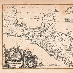
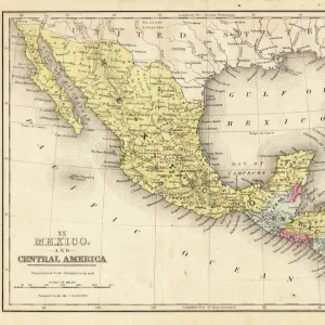
Metal Print : Mexico and Central America map 1867


![]()
Metal Prints from Fine Art Storehouse
Mexico and Central America map 1867
Mitchellas Modern Atlas - Published by E.H. Butler and Co - Philadelphia 1867
Unleash your creativity and transform your space into a visual masterpiece!
THEPALMER
Media ID 13609201
© This content is subject to copyright
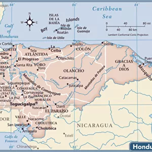
Central America Guatemala Honduras Mexico
16"x20" (51x41cm) Metal Print
Discover the rich history and culture of Mexico and Central America with our stunning Metal Print of the 1867 Mitchell's Modern Atlas map by THEPALMER from the Media Storehouse Fine Art collection. This vintage map, originally published by E.H. Butler and Co in Philadelphia, showcases intricate detail and accurate cartography of the region during that time. The high-quality Metal Print preserves the map's authenticity and vibrant colors, making it a captivating addition to any home or office decor. Travel back in time and explore the history of Mexico and Central America with this beautiful piece of historical art.
Made with durable metal and luxurious printing techniques, our metal photo prints go beyond traditional canvases, adding a cool, modern touch to your space. Wall mount on back. Eco-friendly 100% post-consumer recycled ChromaLuxe aluminum surface. The thickness of the print is 0.045". Featuring a Scratch-resistant surface and Rounded corners. Backing hangers are attached to the back of the print and float the print 1/2-inch off the wall when hung, the choice of hanger may vary depending on size and International orders will come with Float Mount hangers only. Finished with a brilliant white high gloss surface for unsurpassed detail and vibrance. Printed using Dye-Sublimation and for best care we recommend a non-ammonia glass cleaner, water, or isopropyl (rubbing) alcohol to prevent harming the print surface. We recommend using a clean, lint-free cloth to wipe off the print. The ultra-hard surface is scratch-resistant, waterproof and weatherproof. Avoid direct sunlight exposure.
Made with durable metal and luxurious printing techniques, metal prints bring images to life and add a modern touch to any space
Estimated Image Size (if not cropped) is 50.8cm x 40.6cm (20" x 16")
Estimated Product Size is 51.4cm x 41.2cm (20.2" x 16.2")
These are individually made so all sizes are approximate
Artwork printed orientated as per the preview above, with landscape (horizontal) orientation to match the source image.
FEATURES IN THESE COLLECTIONS
> Fine Art Storehouse
> Map
> Historical Maps
> Fine Art Storehouse
> Map
> USA Maps
> Maps and Charts
> Related Images
> North America
> Guatemala
> Maps
> North America
> Guatemala
> Related Images
> North America
> Honduras
> Maps
> North America
> Honduras
> Related Images
> North America
> Mexico
> Maps
> North America
> Mexico
> Related Images
> North America
> United States of America
> Maps
EDITORS COMMENTS
This print showcases a remarkable piece of history - the Mexico and Central America map from 1867. Published by E. H. Butler and Co in Philadelphia, this exquisite artifact takes us back to a time when cartography was an art form in itself. The intricate details etched into this old lithograph are truly awe-inspiring. As we gaze upon this vintage masterpiece, our eyes are drawn to the rich tapestry of geographical features that define these lands. From the rugged mountains of Guatemala to the vast plains of Honduras, every contour is meticulously depicted with precision and skill. This map serves as a testament to the dedication and expertise of those who crafted it. The sepia tones lend an air of nostalgia, transporting us back to an era where exploration was at its peak. It reminds us of a time when adventurers embarked on perilous journeys through uncharted territories, armed only with their maps and unwavering determination. Beyond its historical significance, this artwork also holds aesthetic appeal. The delicate engravings create a visual symphony that captivates our imagination. Its horizontal format allows for easy appreciation of each detail without overwhelming the viewer. "The Mexico and Central America Map 1867" by THEPALMER is not just a mere depiction; it is an invitation to explore forgotten realms and uncover hidden treasures within these ancient lands. Whether you're an avid collector or simply appreciate fine art, this antique lithograph will undoubtedly be cherished for generations to come.
MADE IN THE USA
Safe Shipping with 30 Day Money Back Guarantee
FREE PERSONALISATION*
We are proud to offer a range of customisation features including Personalised Captions, Color Filters and Picture Zoom Tools
SECURE PAYMENTS
We happily accept a wide range of payment options so you can pay for the things you need in the way that is most convenient for you
* Options may vary by product and licensing agreement. Zoomed Pictures can be adjusted in the Cart.