Metal Print > Europe > United Kingdom > England > London > Art > Paintings
Metal Print : Antique map of New Hampshire USA 19th century 1819


![]()
Metal Prints From Fine Art Storehouse
Antique map of New Hampshire USA 19th century 1819
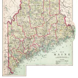
This is a copperplate engraving, a 19th century map of New Hampshire in the United States of America, with hand-coloured borders with Canada, Maine, Massachusetts and Vermont. Captions: 72 Longitude West from London 71. New Hampshire. 3 Longitude East from Philadelphia 4. The map is from Arrowsmith & Lewis, published by John Conrad & Co. and is from A New and Elegant General Atlas published in 1819. The map shows topography, towns, townships, counties and roads
Unleash your creativity and transform your space into a visual masterpiece!
Whiteway
Media ID 15387389
© Whiteway
Copper Engraving Isolated New Hampshire The Americas Image Created 19th Century
16"x20" (51x41cm) Metal Print
Step back in time with our exquisite Antique Map of New Hampshire Metal Print from Media Storehouse. This stunning 19th century masterpiece, originally created by Whiteway, showcases an intricately detailed copperplate engraving of New Hampshire from 1819. The map is adorned with beautifully hand-colored borders featuring Canada, Maine, Massachusetts, and Vermont. Bring history into your home or office with this unique and captivating piece of art. Our high-quality Metal Print preserves the rich details and vibrant colors of the original map, ensuring a timeless addition to your decor. Order yours today and let the story of New Hampshire's history unfold in your space.
Made with durable metal and luxurious printing techniques, our metal photo prints go beyond traditional canvases, adding a cool, modern touch to your space. Wall mount on back. Eco-friendly 100% post-consumer recycled ChromaLuxe aluminum surface. The thickness of the print is 0.045". Featuring a Scratch-resistant surface and Rounded corners. Backing hangers are attached to the back of the print and float the print 1/2-inch off the wall when hung, the choice of hanger may vary depending on size and International orders will come with Float Mount hangers only. Finished with a brilliant white high gloss surface for unsurpassed detail and vibrance. Printed using Dye-Sublimation and for best care we recommend a non-ammonia glass cleaner, water, or isopropyl (rubbing) alcohol to prevent harming the print surface. We recommend using a clean, lint-free cloth to wipe off the print. The ultra-hard surface is scratch-resistant, waterproof and weatherproof. Avoid direct sunlight exposure.
Made with durable metal and luxurious printing techniques, metal prints bring images to life and add a modern touch to any space
Estimated Image Size (if not cropped) is 40.6cm x 50.8cm (16" x 20")
Estimated Product Size is 41.2cm x 51.4cm (16.2" x 20.2")
These are individually made so all sizes are approximate
Artwork printed orientated as per the preview above, with portrait (vertical) orientation to match the source image.
FEATURES IN THESE COLLECTIONS
> Arts
> Artists
> A
> John Arrowsmith
> Europe
> France
> Canton
> Maine
> Europe
> United Kingdom
> England
> Hampshire
> Canada
> Europe
> United Kingdom
> England
> Hampshire
> Related Images
> Europe
> United Kingdom
> England
> Hampshire
> West Town
> Europe
> United Kingdom
> England
> London
> Art
> Paintings
> North America
> Canada
> Maps
> North America
> Canada
> Related Images
> North America
> United States of America
> Maine
> Related Images
EDITORS COMMENTS
This print showcases an exquisite antique map of New Hampshire, USA, dating back to the 19th century. Created in 1819 through a meticulous copperplate engraving technique, this map is a true testament to the artistry and precision of its time. The borders are delicately hand-colored, highlighting the boundaries with Canada, Maine, Massachusetts, and Vermont. The detailed captions on the map reveal fascinating geographical information: longitude measurements from London and Philadelphia pinpointing specific locations within New Hampshire. This particular piece originates from Arrowsmith & Lewis and was published by John Conrad & Co. , featured in their renowned A New and Elegant General Atlas released in 1819. As we delve into this historical treasure trove of knowledge, we discover that it not only depicts topography but also towns, townships, counties, and roads prevalent during that era. It provides a glimpse into how life unfolded in early 19th-century New Hampshire. Preserved meticulously over centuries as an engraved image on paper with vibrant colors adorning its surface; this vertical print transports us back to a time when cartography was both science and art. Its isolation against a blank background allows us to focus solely on the intricate details presented by this copper engraving. A remarkable piece for collectors or enthusiasts alike; Whiteway's reproduction ensures that this slice of American history remains accessible for generations to come.
MADE IN THE USA
Safe Shipping with 30 Day Money Back Guarantee
FREE PERSONALISATION*
We are proud to offer a range of customisation features including Personalised Captions, Color Filters and Picture Zoom Tools
SECURE PAYMENTS
We happily accept a wide range of payment options so you can pay for the things you need in the way that is most convenient for you
* Options may vary by product and licensing agreement. Zoomed Pictures can be adjusted in the Basket.