Metal Print > Arts > Street art graffiti > Digital art > Vector illustrations
Metal Print : Roseville California US City Street Map


![]()
Metal Prints From Fine Art Storehouse
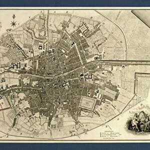
Roseville California US City Street Map
Vector Illustration of a City Street Map of Roseville, California, USA. Scale 1:60, 000.
All source data is in the public domain.
U.S. Geological Survey, US Topo
Used Layers:
USGS The National Map: National Hydrography Dataset (NHD)
USGS The National Map: National Transportation Dataset (NTD)
Unleash your creativity and transform your space into a visual masterpiece!
Frank Ramspott
Media ID 15055089
© Frank Ramspott, all rights reserved
Aerial View California City Map Computer Graphic Directly Above Downtown District Gray Road Map Text Digitally Generated Image Green Color White Color
20"x24" (61x51cm) Metal Print
Discover the charm of Roseville, California with our stunning Metal Print of the City Street Map by Frank Ramspott from Media Storehouse. This exquisite piece, sourced from Fine Art Storehouse, features a detailed vector illustration of the city map at a scale of 1:60,000. Each Metal Print is meticulously crafted, bringing the vibrant colors and intricate lines of this U.S. city map to life. With its durable and water-resistant finish, this unique art piece is perfect for adding a touch of personalized sophistication to any room in your home or office. Explore the beauty of Roseville like never before with Media Storehouse's Metal Print.
Made with durable metal and luxurious printing techniques, our metal photo prints go beyond traditional canvases, adding a cool, modern touch to your space. Wall mount on back. Eco-friendly 100% post-consumer recycled ChromaLuxe aluminum surface. The thickness of the print is 0.045". Featuring a Scratch-resistant surface and Rounded corners. Backing hangers are attached to the back of the print and float the print 1/2-inch off the wall when hung, the choice of hanger may vary depending on size and International orders will come with Float Mount hangers only. Finished with a brilliant white high gloss surface for unsurpassed detail and vibrance. Printed using Dye-Sublimation and for best care we recommend a non-ammonia glass cleaner, water, or isopropyl (rubbing) alcohol to prevent harming the print surface. We recommend using a clean, lint-free cloth to wipe off the print. The ultra-hard surface is scratch-resistant, waterproof and weatherproof. Avoid direct sunlight exposure.
Made with durable metal and luxurious printing techniques, metal prints bring images to life and add a modern touch to any space
Estimated Image Size (if not cropped) is 50.8cm x 60.9cm (20" x 24")
Estimated Product Size is 51.4cm x 61.5cm (20.2" x 24.2")
These are individually made so all sizes are approximate
Artwork printed orientated as per the preview above, with portrait (vertical) orientation to match the source image.
FEATURES IN THESE COLLECTIONS
> Aerial Photography
> Related Images
> Animals
> Insects
> Hemiptera
> Green Scale
> Animals
> Mammals
> Cricetidae
> California Mouse
> Arts
> Contemporary art
> Digital artwork
> Street art
> Arts
> Landscape paintings
> Waterfall and river artworks
> River artworks
> Arts
> Portraits
> Pop art gallery
> Street art portraits
> Arts
> Street art graffiti
> Digital art
> Digital paintings
> Arts
> Street art graffiti
> Digital art
> Vector illustrations
> Maps and Charts
> Geological Map
> Maps and Charts
> Related Images
EDITORS COMMENTS
This print showcases a detailed and vibrant city street map of Roseville, California, USA. With a scale of 1:60,000, this vector illustration provides an intricate depiction of the downtown district, river, lake, streets, and roads that compose this charming city. The design is digitally generated with no people present in the image. The artist behind this masterpiece is Frank Ramspott who skillfully utilized various layers from reliable sources to create this visually stunning piece. The USGS National Map's National Hydrography Dataset (NHD) and National Transportation Dataset (NTD) were instrumental in ensuring accuracy and precision in mapping out the city's features. Incorporating shades of gray, green, blue, and white colors into the composition adds depth and enhances its aesthetic appeal. This aerial view perspective allows viewers to appreciate the physical geography of Roseville while also highlighting its urban layout. As a result of utilizing publicly available source data from reputable organizations such as U. S. Geological Survey (USGS), including US Topo maps which are freely accessible to all individuals interested in cartography or geographical exploration purposes; this artwork falls within fair use guidelines for non-commercial use only. Overall, Frank Ramspott's digital creation beautifully captures the essence of Roseville by presenting an intricately designed city street map that will surely captivate any admirer of art or geography alike.
MADE IN THE USA
Safe Shipping with 30 Day Money Back Guarantee
FREE PERSONALISATION*
We are proud to offer a range of customisation features including Personalised Captions, Color Filters and Picture Zoom Tools
SECURE PAYMENTS
We happily accept a wide range of payment options so you can pay for the things you need in the way that is most convenient for you
* Options may vary by product and licensing agreement. Zoomed Pictures can be adjusted in the Basket.