Metal Print > Maps and Charts > Americas
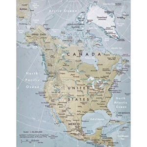
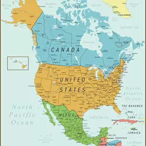
Metal Print : Political map of North America


Resolution may be poor at this size (104 DPI)
![]()
Metal Prints from Fine Art Storehouse
Political map of North America
Vector illustration of the political map of North America.
Reference map was created by the US Central Intelligence Agency and is available as a public domain map at the University of Texas Libraries website.
https:/cia.gov/library/publications/resources/the-world-factbook/graphics/ref_maps/political/pdf/north_america.pdf
Unleash your creativity and transform your space into a visual masterpiece!
Media ID 15192878
20"x24" (61x51cm) Metal Print
Bring a piece of geopolitical history into your home or office with our stunning Metal Prints from Media Storehouse. This particular design features an intricately detailed vector illustration of the Political Map of North America, sourced from the US Central Intelligence Agency. Each Metal Print is meticulously crafted, giving the image a three-dimensional effect that adds depth and dimension to your space. The vibrant colors and sharp lines of the map are beautifully preserved, making it a captivating conversation starter. Upgrade your decor with this unique and thought-provoking piece of art.
Made with durable metal and luxurious printing techniques, our metal photo prints go beyond traditional canvases, adding a cool, modern touch to your space. Wall mount on back. Eco-friendly 100% post-consumer recycled ChromaLuxe aluminum surface. The thickness of the print is 0.045". Featuring a Scratch-resistant surface and Rounded corners. Backing hangers are attached to the back of the print and float the print 1/2-inch off the wall when hung, the choice of hanger may vary depending on size and International orders will come with Float Mount hangers only. Finished with a brilliant white high gloss surface for unsurpassed detail and vibrance. Printed using Dye-Sublimation and for best care we recommend a non-ammonia glass cleaner, water, or isopropyl (rubbing) alcohol to prevent harming the print surface. We recommend using a clean, lint-free cloth to wipe off the print. The ultra-hard surface is scratch-resistant, waterproof and weatherproof. Avoid direct sunlight exposure.
Made with durable metal and luxurious printing techniques, metal prints bring images to life and add a modern touch to any space
Estimated Image Size (if not cropped) is 50.8cm x 60.9cm (20" x 24")
Estimated Product Size is 51.4cm x 61.5cm (20.2" x 24.2")
These are individually made so all sizes are approximate
Artwork printed orientated as per the preview above, with portrait (vertical) orientation to match the source image.
FEATURES IN THESE COLLECTIONS
> Fine Art Storehouse
> Map
> Reference Maps
> Maps and Charts
> Related Images
> Maps and Charts
> World
> North America
> Related Images
EDITORS COMMENTS
This print showcases a meticulously crafted political map of North America, rendered in stunning vector illustration. With its intricate details and vibrant colors, this artwork offers an immersive journey through the diverse nations that make up this vast continent. Derived from the reference map created by the US Central Intelligence Agency, this piece is a testament to both accuracy and artistic interpretation. The University of Texas Libraries website has made it available as a public domain map, ensuring accessibility for all who wish to explore and appreciate its beauty. From the snow-capped peaks of Canada's Rocky Mountains to the sprawling deserts of Mexico, every corner of North America is represented with utmost precision. Each country stands out distinctly with its own unique color scheme and borders clearly defined. This visual representation not only serves as an educational tool but also sparks curiosity about the rich history, culture, and geography that shape these lands. Whether displayed in a classroom or adorning your living space, this print invites you to embark on an intellectual voyage across North America's vast expanse. It serves as a reminder of our interconnectedness within this continent while celebrating the diversity that unites us all
MADE IN THE USA
Safe Shipping with 30 Day Money Back Guarantee
FREE PERSONALISATION*
We are proud to offer a range of customisation features including Personalised Captions, Color Filters and Picture Zoom Tools
SECURE PAYMENTS
We happily accept a wide range of payment options so you can pay for the things you need in the way that is most convenient for you
* Options may vary by product and licensing agreement. Zoomed Pictures can be adjusted in the Cart.