Metal Print > Arts > Landscape paintings > Waterfall and river artworks > River artworks
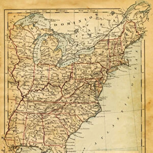
Metal Print : Mississippi river map 1895


![]()
Metal Prints from Fine Art Storehouse
Mississippi river map 1895
Meyers Konversations-Lexikon. Ein Nachschlagewerk des allgemeinen Wissens, 5th edition 17 volumes Bibliographisches Institut - Leipzig 1895-1897
Unleash your creativity and transform your space into a visual masterpiece!
THEPALMER
Media ID 18106761
© 2014 Roberto Adrian Photography
16"x24" (61x41cm) Metal Print
Discover the historical charm of the Mississippi River with our stunning Metal Print from Media Storehouse's Fine Art Collection. This exquisite piece showcases an 1895 map of the Mississippi River, originally published in the renowned Meyers Konversations-Lexikon. Each Metal Print is meticulously crafted with vibrant colors and exceptional detail, ensuring a museum-quality finish. Bring a piece of history into your home or office and add a unique touch to your decor with this captivating and intriguing Mississippi River map from THEPALMER.
Made with durable metal and luxurious printing techniques, our metal photo prints go beyond traditional canvases, adding a cool, modern touch to your space. Wall mount on back. Eco-friendly 100% post-consumer recycled ChromaLuxe aluminum surface. The thickness of the print is 0.045". Featuring a Scratch-resistant surface and Rounded corners. Backing hangers are attached to the back of the print and float the print 1/2-inch off the wall when hung, the choice of hanger may vary depending on size and International orders will come with Float Mount hangers only. Finished with a brilliant white high gloss surface for unsurpassed detail and vibrance. Printed using Dye-Sublimation and for best care we recommend a non-ammonia glass cleaner, water, or isopropyl (rubbing) alcohol to prevent harming the print surface. We recommend using a clean, lint-free cloth to wipe off the print. The ultra-hard surface is scratch-resistant, waterproof and weatherproof. Avoid direct sunlight exposure.
Made with durable metal and luxurious printing techniques, metal prints bring images to life and add a modern touch to any space
Estimated Product Size is 41.2cm x 61.5cm (16.2" x 24.2")
These are individually made so all sizes are approximate
Artwork printed orientated as per the preview above, with portrait (vertical) orientation to match the source image.
FEATURES IN THESE COLLECTIONS
> Fine Art Storehouse
> Map
> Historical Maps
> Arts
> Landscape paintings
> Waterfall and river artworks
> River artworks
> Maps and Charts
> Related Images
EDITORS COMMENTS
In this photo print, titled "Mississippi River Map 1895". THEPALMER takes us on a visual journey back in time to the late 19th century. The image showcases an intricately detailed map of the mighty Mississippi River as it appeared in 1895, sourced from Meyers Konversations-Lexikon's renowned fifth edition. The map itself is a testament to both historical significance and artistic craftsmanship. Every bend and curve of the river is meticulously depicted, allowing viewers to trace its course through various states and cities along its banks. The level of detail transports us to an era when maps were not just navigational tools but also works of art that captured the essence of a place. As we gaze upon this vintage treasure, our imagination runs wild with thoughts of steamboats majestically cruising down the river, bustling ports filled with trade and commerce, and communities thriving along its shores. It serves as a reminder of how vital the Mississippi River was for transportation, trade routes, and economic development during that period. THEPALMER's skillful capture brings out every intricate line and faded hue present on this aged piece. This print allows us to appreciate not only the historical context but also serves as a beautiful decorative addition for any space seeking a touch of nostalgia or admiration for cartographic artistry.
MADE IN THE USA
Safe Shipping with 30 Day Money Back Guarantee
FREE PERSONALISATION*
We are proud to offer a range of customisation features including Personalised Captions, Color Filters and Picture Zoom Tools
SECURE PAYMENTS
We happily accept a wide range of payment options so you can pay for the things you need in the way that is most convenient for you
* Options may vary by product and licensing agreement. Zoomed Pictures can be adjusted in the Cart.