Metal Print > Arts > Artists > D > Lawrence Duncan
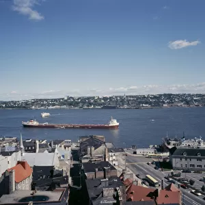
Metal Print : Map of the St Lawrence river, 18th Century


![]()
Metal Prints From Fine Art Storehouse
Map of the St Lawrence river, 18th Century
Vintage engraving of a Map of the St Lawrence river, 18th Century
Unleash your creativity and transform your space into a visual masterpiece!
duncan1890
Media ID 18563422
© of Duncan P Walker
18th Century 18th Century Style Canada
16"x20" (51x41cm) Metal Print
Step back in time with our exquisite Metal Print of a Vintage Engraving of the St. Lawrence River Map by duncan1890 from our Media Storehouse collection. This beautifully preserved 18th-century cartographic masterpiece showcases intricate details of the river's winding path and surrounding geography. The high-quality metal print process enhances the intricate lines and textures of the original engraving, ensuring a stunning and long-lasting addition to your home or office decor. Bring history to life with this captivating piece of art.
Made with durable metal and luxurious printing techniques, our metal photo prints go beyond traditional canvases, adding a cool, modern touch to your space. Wall mount on back. Eco-friendly 100% post-consumer recycled ChromaLuxe aluminum surface. The thickness of the print is 0.045". Featuring a Scratch-resistant surface and Rounded corners. Backing hangers are attached to the back of the print and float the print 1/2-inch off the wall when hung, the choice of hanger may vary depending on size and International orders will come with Float Mount hangers only. Finished with a brilliant white high gloss surface for unsurpassed detail and vibrance. Printed using Dye-Sublimation and for best care we recommend a non-ammonia glass cleaner, water, or isopropyl (rubbing) alcohol to prevent harming the print surface. We recommend using a clean, lint-free cloth to wipe off the print. The ultra-hard surface is scratch-resistant, waterproof and weatherproof. Avoid direct sunlight exposure.
Made with durable metal and luxurious printing techniques, metal prints bring images to life and add a modern touch to any space
Estimated Image Size (if not cropped) is 50.8cm x 40.6cm (20" x 16")
Estimated Product Size is 51.4cm x 41.2cm (20.2" x 16.2")
These are individually made so all sizes are approximate
Artwork printed orientated as per the preview above, with landscape (horizontal) orientation to match the source image.
FEATURES IN THESE COLLECTIONS
> Fine Art Storehouse
> Map
> Historical Maps
> Arts
> Artists
> D
> Lawrence Duncan
> Arts
> Landscape paintings
> Waterfall and river artworks
> River artworks
> Maps and Charts
> Related Images
> North America
> Canada
> Maps
> North America
> Canada
> Related Images
EDITORS COMMENTS
This vintage engraving takes us back to the 18th century, offering a glimpse into the intricate details of a map showcasing the majestic St Lawrence River. The black and white aesthetic adds an air of nostalgia and authenticity to this antique print, allowing us to appreciate its historical significance. The St Lawrence River, stretching across Canada, has long been an essential waterway for trade and exploration. This meticulously crafted map beautifully captures its meandering path through various provinces and territories. Every curve and bend is delicately etched onto the paper, highlighting key landmarks along its course. As we examine this piece closely, we are transported back in time when explorers braved these waters in search of new frontiers. The 18th-century style evokes a sense of adventure as we imagine sailors navigating their ships along this vital route. Duncan1890's attention to detail truly shines through in this artwork. Each stroke tells a story of discovery and perseverance that shaped Canada's history. Whether you're a history enthusiast or simply captivated by the beauty of cartography, this print is sure to ignite your imagination. Displaying this exquisite piece on your wall will not only add elegance but also serve as a conversation starter for guests who share your appreciation for artistry from bygone eras. Let yourself be transported back in time with this remarkable depiction of the St Lawrence River – an enduring symbol of exploration and connection throughout centuries past.
MADE IN THE USA
Safe Shipping with 30 Day Money Back Guarantee
FREE PERSONALISATION*
We are proud to offer a range of customisation features including Personalised Captions, Color Filters and Picture Zoom Tools
SECURE PAYMENTS
We happily accept a wide range of payment options so you can pay for the things you need in the way that is most convenient for you
* Options may vary by product and licensing agreement. Zoomed Pictures can be adjusted in the Basket.