Metal Print > Animals > Mammals > Muridae > Western Mouse
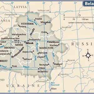
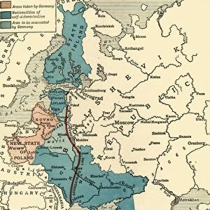
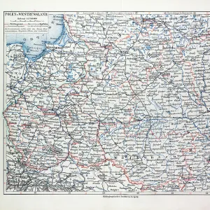
Metal Print : Map of Poland and Western Russia (Belarus), lithograph, published 1897
, lithograph, published 1897")


![]()
Metal Prints from Fine Art Storehouse
Map of Poland and Western Russia (Belarus), lithograph, published 1897
Historical topographic map of Poland and Western Russia (Belarus). Lithograph, published in 1897
Unleash your creativity and transform your space into a visual masterpiece!
ZU_09
Media ID 18292209
16"x20" (51x41cm) Metal Print
Step back in time with our stunning Historical Topographic Map of Poland and Western Russia (Belarus), a beautiful lithograph published in 1897 by ZU_09 from our Media Storehouse Fine Art collection. This intricately detailed map showcases the historical borders and geography of the region during that era, making it a must-have for history enthusiasts, collectors, and those with a deep appreciation for the rich cultural heritage of Europe. Bring this piece of history into your home or office and add a touch of sophistication and character to your space.
Made with durable metal and luxurious printing techniques, our metal photo prints go beyond traditional canvases, adding a cool, modern touch to your space. Wall mount on back. Eco-friendly 100% post-consumer recycled ChromaLuxe aluminum surface. The thickness of the print is 0.045". Featuring a Scratch-resistant surface and Rounded corners. Backing hangers are attached to the back of the print and float the print 1/2-inch off the wall when hung, the choice of hanger may vary depending on size and International orders will come with Float Mount hangers only. Finished with a brilliant white high gloss surface for unsurpassed detail and vibrance. Printed using Dye-Sublimation and for best care we recommend a non-ammonia glass cleaner, water, or isopropyl (rubbing) alcohol to prevent harming the print surface. We recommend using a clean, lint-free cloth to wipe off the print. The ultra-hard surface is scratch-resistant, waterproof and weatherproof. Avoid direct sunlight exposure.
Made with durable metal and luxurious printing techniques, metal prints bring images to life and add a modern touch to any space
Estimated Image Size (if not cropped) is 50.8cm x 40.6cm (20" x 16")
Estimated Product Size is 51.4cm x 41.2cm (20.2" x 16.2")
These are individually made so all sizes are approximate
Artwork printed orientated as per the preview above, with landscape (horizontal) orientation to match the source image.
FEATURES IN THESE COLLECTIONS
> Fine Art Storehouse
> Map
> Historical Maps
> Animals
> Mammals
> Muridae
> Western Mouse
> Europe
> Belarus
> Related Images
> Europe
> Poland
> Related Images
> Europe
> Russia
> Related Images
EDITORS COMMENTS
This lithograph, titled "Map of Poland and Western Russia (Belarus)" takes us on a journey back in time to the year 1897. A remarkable piece of historical topographic art, it offers a glimpse into the intricate cartography of Eastern Europe during that era. The print showcases the meticulous craftsmanship and attention to detail employed by ZU_09, the talented artist behind this masterpiece. The map itself is an exquisite representation of Poland and Western Russia (Belarus), capturing their geographical features with astonishing accuracy. Every contour, river, mountain range, and city is meticulously depicted, allowing viewers to immerse themselves in these lands as they were over a century ago. As we gaze upon this lithograph, we are transported to a different time - one where borders may have shifted but the beauty of these landscapes remains eternal. It serves as both an educational tool for historians and geographers alike while also appealing to those with an appreciation for fine art. Whether displayed in a study or adorning the walls of a history enthusiast's home, this print stands as a testament to human curiosity and our desire to explore beyond our own horizons. It invites us to reflect on how much has changed since its creation while reminding us that some things endure through time - like our fascination with maps that tell stories about places long gone yet forever etched in memory.
MADE IN THE USA
Safe Shipping with 30 Day Money Back Guarantee
FREE PERSONALISATION*
We are proud to offer a range of customisation features including Personalised Captions, Color Filters and Picture Zoom Tools
SECURE PAYMENTS
We happily accept a wide range of payment options so you can pay for the things you need in the way that is most convenient for you
* Options may vary by product and licensing agreement. Zoomed Pictures can be adjusted in the Cart.