Metal Print > North America > United States of America > New York > New York > Maps
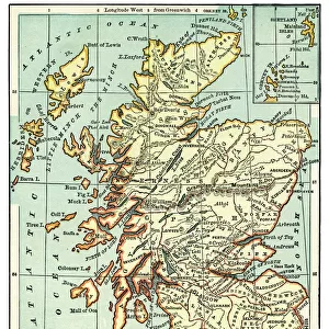
Metal Print : Map of Europe 1875


![]()
Metal Prints From Fine Art Storehouse
Map of Europe 1875
Elementary Geography Course by William Swinton - New York 1875
Unleash your creativity and transform your space into a visual masterpiece!
THEPALMER
Media ID 19834497
© 2014 Roberto Adrian Photography
16"x20" (51x41cm) Metal Print
Discover the rich history of European geography with our stunning Metal Print of the Map of Europe from 1875, created by THEPALMER for the Elementary Geography Course by William Swinton, New York. This exquisite metal print showcases intricate details of Europe's political boundaries and geographical features during that era. The high-quality metal print not only adds an elegant touch to your home or office decor but also serves as an educational piece, making it a perfect addition for history enthusiasts, educators, and geography lovers. Experience the beauty of the past with our premium Metal Print of the Map of Europe 1875.
Made with durable metal and luxurious printing techniques, our metal photo prints go beyond traditional canvases, adding a cool, modern touch to your space. Wall mount on back. Eco-friendly 100% post-consumer recycled ChromaLuxe aluminum surface. The thickness of the print is 0.045". Featuring a Scratch-resistant surface and Rounded corners. Backing hangers are attached to the back of the print and float the print 1/2-inch off the wall when hung, the choice of hanger may vary depending on size and International orders will come with Float Mount hangers only. Finished with a brilliant white high gloss surface for unsurpassed detail and vibrance. Printed using Dye-Sublimation and for best care we recommend a non-ammonia glass cleaner, water, or isopropyl (rubbing) alcohol to prevent harming the print surface. We recommend using a clean, lint-free cloth to wipe off the print. The ultra-hard surface is scratch-resistant, waterproof and weatherproof. Avoid direct sunlight exposure.
Made with durable metal and luxurious printing techniques, metal prints bring images to life and add a modern touch to any space
Estimated Image Size (if not cropped) is 50.8cm x 40.6cm (20" x 16")
Estimated Product Size is 51.4cm x 41.2cm (20.2" x 16.2")
These are individually made so all sizes are approximate
Artwork printed orientated as per the preview above, with landscape (horizontal) orientation to match the source image.
FEATURES IN THESE COLLECTIONS
> Fine Art Storehouse
> Map
> Historical Maps
> Maps and Charts
> Related Images
> North America
> United States of America
> New York
> New York
> Maps
> North America
> United States of America
> New York
> Related Images
EDITORS COMMENTS
This print titled "Map of Europe 1875" takes us on a journey back in time to the fascinating era of the late 19th century. Created by William Swinton for his renowned Elementary Geography Course, this map offers a glimpse into the intricate world of cartography as it existed in New York City during 1875. The image showcases an exquisite blend of artistry and precision, capturing every detail with remarkable clarity. The carefully drawn borders delineate each European country, while vibrant colors bring life to the diverse landscapes and bodies of water that shape this continent's rich history. As we explore this vintage masterpiece, we are transported to an era when Europe was undergoing significant political and social transformations. From the vast Russian Empire stretching across Eastern Europe to the mighty British Isles reigning supreme over their maritime empire, every nation represents a piece of a complex geopolitical puzzle waiting to be unraveled. Beyond its historical significance, "Map of Europe 1875" is also a testament to human curiosity and our innate desire for knowledge. It serves as a reminder that maps have always been essential tools for exploration and understanding our place in the world. "The Palmer" known for their exceptional collection at Fine Art Storehouse, has once again curated an extraordinary piece that not only captivates but educates viewers about our shared past. This print invites us to delve into history's depths while appreciating both its artistic beauty and educational value.
MADE IN THE USA
Safe Shipping with 30 Day Money Back Guarantee
FREE PERSONALISATION*
We are proud to offer a range of customisation features including Personalised Captions, Color Filters and Picture Zoom Tools
SECURE PAYMENTS
We happily accept a wide range of payment options so you can pay for the things you need in the way that is most convenient for you
* Options may vary by product and licensing agreement. Zoomed Pictures can be adjusted in the Basket.