Metal Print > Asia > Japan > Maps
Metal Print : Map of China and Japan 1900


![]()
Metal Prints from Fine Art Storehouse
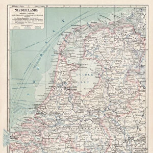
Map of China and Japan 1900
Meyers hand-Atlas Leipzig und Wien Verlag des Bibliographischen Instituts 1900
Unleash your creativity and transform your space into a visual masterpiece!
THEPALMER
Media ID 18106921
© 2014 Roberto Adrian Photography
16"x20" (51x41cm) Metal Print
Discover the rich history and cultural connection between China and Japan with our stunning Metal Print of the Map of China and Japan from THEPALMER's Map of the World, published by Meyers Hand-Atlas Leipzig und Wien Verlag des Bibliographischen Instituts in 1900. This exquisite piece of historical cartography is now transformed into a modern work of art with our high-quality Metal Print. The vibrant colors and sharp details pop against the sleek, metallic surface, making it a beautiful addition to any home or office. Each Metal Print is printed using archival inks and coated with a protective layer to ensure long-lasting durability. Bring a piece of history into your space with this unique and captivating Map of China and Japan from the Media Storehouse range of Metal Prints.
Made with durable metal and luxurious printing techniques, our metal photo prints go beyond traditional canvases, adding a cool, modern touch to your space. Wall mount on back. Eco-friendly 100% post-consumer recycled ChromaLuxe aluminum surface. The thickness of the print is 0.045". Featuring a Scratch-resistant surface and Rounded corners. Backing hangers are attached to the back of the print and float the print 1/2-inch off the wall when hung, the choice of hanger may vary depending on size and International orders will come with Float Mount hangers only. Finished with a brilliant white high gloss surface for unsurpassed detail and vibrance. Printed using Dye-Sublimation and for best care we recommend a non-ammonia glass cleaner, water, or isopropyl (rubbing) alcohol to prevent harming the print surface. We recommend using a clean, lint-free cloth to wipe off the print. The ultra-hard surface is scratch-resistant, waterproof and weatherproof. Avoid direct sunlight exposure.
Made with durable metal and luxurious printing techniques, metal prints bring images to life and add a modern touch to any space
Estimated Image Size (if not cropped) is 50.8cm x 40.6cm (20" x 16")
Estimated Product Size is 51.4cm x 41.2cm (20.2" x 16.2")
These are individually made so all sizes are approximate
Artwork printed orientated as per the preview above, with landscape (horizontal) orientation to match the source image.
FEATURES IN THESE COLLECTIONS
> Fine Art Storehouse
> Map
> Historical Maps
> Asia
> Japan
> Related Images
EDITORS COMMENTS
In this print titled "Map of China and Japan 1900" we are transported back in time to the turn of the 20th century. The image, sourced from Meyers Hand-Atlas Leipzig und Wien Verlag des Bibliographischen Instituts in 1900, offers a fascinating glimpse into the geopolitical landscape of East Asia during that era. The map itself is a testament to meticulous craftsmanship and attention to detail. With intricate lines and delicate shading, it beautifully depicts the vast territories of China and Japan as they stood at the dawn of a new century. Every contour, river, mountain range, and city is meticulously marked with precision. This historical artifact not only serves as an educational tool but also sparks curiosity about how these nations have evolved over time. It invites us to ponder upon their rich cultural heritage, complex histories, and enduring traditions. "The Map of China and Japan 1900" by THEPALMER captures our imagination with its vintage charm while simultaneously reminding us of the ever-changing nature of borders and alliances. As we gaze upon this print, we find ourselves contemplating how these two countries have navigated through countless transformations since then – politically, socially, economically – shaping their destinies amidst both triumphs and challenges. With its timeless appeal and historical significance preserved through this stunning print from Fine Art Storehouse's collection, "The Map of China and Japan 1900" allows us to embark on a visual journey into an era long gone yet forever imprinted on our collective
MADE IN THE USA
Safe Shipping with 30 Day Money Back Guarantee
FREE PERSONALISATION*
We are proud to offer a range of customisation features including Personalised Captions, Color Filters and Picture Zoom Tools
SECURE PAYMENTS
We happily accept a wide range of payment options so you can pay for the things you need in the way that is most convenient for you
* Options may vary by product and licensing agreement. Zoomed Pictures can be adjusted in the Cart.