Metal Print > North America > United States of America > New York > New York > Maps
Metal Print : Canada British America map of 1869


![]()
Metal Prints From Fine Art Storehouse
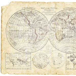
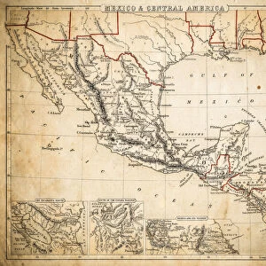
Canada British America map of 1869
Cornells Grammar School Geography By S.S. Cornell - New York 1869
Unleash your creativity and transform your space into a visual masterpiece!
THEPALMER
Media ID 18106821
© 2014 Roberto Adrian Photography
16"x20" (51x41cm) Metal Print
Discover history with our stunning Metal Print of the Canada British America Map from ThePalmer, originally published in S.S. Cornell's Cornell's Grammar School Geography in New York, 1869. This vintage map showcases intricate detail and historical accuracy, transporting you back in time. Our high-quality Metal Prints are not just a decorative piece, they are a conversation starter and a reminder of the rich history of Canada and North America. Order yours today and add a touch of history to your home or office.
Made with durable metal and luxurious printing techniques, our metal photo prints go beyond traditional canvases, adding a cool, modern touch to your space. Wall mount on back. Eco-friendly 100% post-consumer recycled ChromaLuxe aluminum surface. The thickness of the print is 0.045". Featuring a Scratch-resistant surface and Rounded corners. Backing hangers are attached to the back of the print and float the print 1/2-inch off the wall when hung, the choice of hanger may vary depending on size and International orders will come with Float Mount hangers only. Finished with a brilliant white high gloss surface for unsurpassed detail and vibrance. Printed using Dye-Sublimation and for best care we recommend a non-ammonia glass cleaner, water, or isopropyl (rubbing) alcohol to prevent harming the print surface. We recommend using a clean, lint-free cloth to wipe off the print. The ultra-hard surface is scratch-resistant, waterproof and weatherproof. Avoid direct sunlight exposure.
Made with durable metal and luxurious printing techniques, metal prints bring images to life and add a modern touch to any space
Estimated Image Size (if not cropped) is 50.8cm x 40.6cm (20" x 16")
Estimated Product Size is 51.4cm x 41.2cm (20.2" x 16.2")
These are individually made so all sizes are approximate
Artwork printed orientated as per the preview above, with landscape (horizontal) orientation to match the source image.
FEATURES IN THESE COLLECTIONS
> Fine Art Storehouse
> Map
> Historical Maps
> Maps and Charts
> Related Images
> North America
> Canada
> Maps
> North America
> Canada
> Related Images
> North America
> United States of America
> New York
> New York
> Maps
> North America
> United States of America
> New York
> Related Images
EDITORS COMMENTS
This print showcases a historical gem, the Canada British America map of 1869. A true testament to the rich tapestry of our past, this piece is taken from "Cornells Grammar School Geography" by S. S. Cornell - New York 1869. The intricate details and exquisite craftsmanship transport us back to an era when cartography was both an art form and a scientific endeavor. The map itself is a visual feast for the eyes, meticulously depicting the vast expanse of Canada's territories during that time. Every contour and boundary line tells a story of exploration, colonization, and cultural exchange. It serves as a window into an age where geographical knowledge was expanding rapidly. The choice to present this particular photograph in black and white adds depth and nostalgia to its overall aesthetic appeal. The monochromatic tones lend themselves perfectly to capturing the essence of history frozen in time. "ThePALMER" through their lens, has masterfully captured not only the physicality but also the spirit encapsulated within this vintage map print. This artwork invites us on a journey through time while simultaneously reminding us of how far we have come as nations united under one flag. Whether you are an avid historian or simply appreciate fine art with historical significance, this print promises to be an intriguing addition to any collection or space it graces – offering endless opportunities for reflection upon our shared heritage.
MADE IN THE USA
Safe Shipping with 30 Day Money Back Guarantee
FREE PERSONALISATION*
We are proud to offer a range of customisation features including Personalised Captions, Color Filters and Picture Zoom Tools
SECURE PAYMENTS
We happily accept a wide range of payment options so you can pay for the things you need in the way that is most convenient for you
* Options may vary by product and licensing agreement. Zoomed Pictures can be adjusted in the Basket.