Metal Print > North America > Honduras > Maps
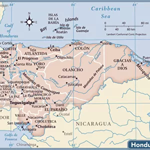
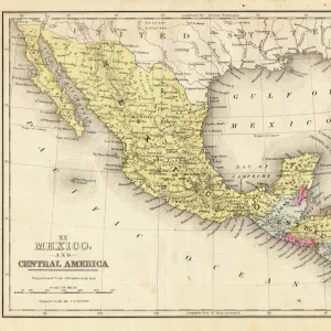
Metal Print : Antique map of Honduras Yucatan and Mexico 1671


![]()
Metal Prints From Fine Art Storehouse
Antique map of Honduras Yucatan and Mexico 1671
Map of Honduras Yucatan and Mexico
Original edition from my own archives
Source: America New World Empires 1671
Unleash your creativity and transform your space into a visual masterpiece!
Grafissimo
Media ID 18356571
16"x20" (51x41cm) Metal Print
Step back in time with our exquisite Metal Print of the Antique Map of Honduras Yucatan and Mexico, dating back to 1671. This stunning piece, sourced from Grafissimo's America New World Empires edition, showcases intricate detail and vibrant colors. The map's aged patina adds an authentic touch, transporting you back to an era of exploration and discovery. Display this captivating work of art in your home or office, and let the rich history of the New World come alive.
Made with durable metal and luxurious printing techniques, our metal photo prints go beyond traditional canvases, adding a cool, modern touch to your space. Wall mount on back. Eco-friendly 100% post-consumer recycled ChromaLuxe aluminum surface. The thickness of the print is 0.045". Featuring a Scratch-resistant surface and Rounded corners. Backing hangers are attached to the back of the print and float the print 1/2-inch off the wall when hung, the choice of hanger may vary depending on size and International orders will come with Float Mount hangers only. Finished with a brilliant white high gloss surface for unsurpassed detail and vibrance. Printed using Dye-Sublimation and for best care we recommend a non-ammonia glass cleaner, water, or isopropyl (rubbing) alcohol to prevent harming the print surface. We recommend using a clean, lint-free cloth to wipe off the print. The ultra-hard surface is scratch-resistant, waterproof and weatherproof. Avoid direct sunlight exposure.
Made with durable metal and luxurious printing techniques, metal prints bring images to life and add a modern touch to any space
Estimated Image Size (if not cropped) is 50.8cm x 40.6cm (20" x 16")
Estimated Product Size is 51.4cm x 41.2cm (20.2" x 16.2")
These are individually made so all sizes are approximate
Artwork printed orientated as per the preview above, with landscape (horizontal) orientation to match the source image.
FEATURES IN THESE COLLECTIONS
> Fine Art Storehouse
> Map
> Historical Maps
> Maps and Charts
> Related Images
> Maps and Charts
> World
> North America
> Honduras
> Maps
> North America
> Honduras
> Related Images
> North America
> Mexico
> Related Images
EDITORS COMMENTS
This print showcases an exquisite antique map of Honduras, Yucatan, and Mexico from the year 1671. A true gem from my personal archives, this original edition is a testament to the rich history and exploration of the New World Empires during that era. The intricate details and delicate craftsmanship of this map are truly awe-inspiring. As you gaze upon this piece, you can't help but be transported back in time to an age of discovery and adventure. Every line on the map tells a story - revealing ancient cities, uncharted territories, and vast expanses waiting to be explored. It's as if you can almost hear the whispers of explorers like Hernán Cortés or Francisco de Montejo planning their expeditions through these lands. The warm hues and aged texture add a sense of authenticity to this remarkable print. It serves as a reminder not only of our past but also of how far we have come in understanding our world today. Whether you're a history enthusiast or simply appreciate fine art, this piece will undoubtedly captivate your imagination. With its timeless appeal and historical significance, "Antique Map of Honduras Yucatan and Mexico 1671" by Grafissimo is more than just a decorative item; it's a window into another time – an invitation to explore the stories hidden within its carefully drawn borders.
MADE IN THE USA
Safe Shipping with 30 Day Money Back Guarantee
FREE PERSONALISATION*
We are proud to offer a range of customisation features including Personalised Captions, Color Filters and Picture Zoom Tools
SECURE PAYMENTS
We happily accept a wide range of payment options so you can pay for the things you need in the way that is most convenient for you
* Options may vary by product and licensing agreement. Zoomed Pictures can be adjusted in the Basket.