Metal Print > Europe > Italy > Lazio > Rome
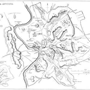
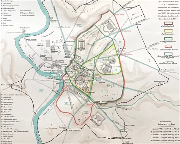
Metal Print : Ancient rome, regions map of Rome


![]()
Metal Prints from Fine Art Storehouse
Ancient rome, regions map of Rome
Illustration from 19th century
Unleash your creativity and transform your space into a visual masterpiece!
clu
Media ID 18298719
16"x20" (51x41cm) Metal Print
Step back in time with our exquisite Ancient Rome Metal Print from the Media Storehouse collection at Fine Art Storehouse. This captivating 19th century illustration of the Roman regions map by Clu transports you to the heart of the ancient world. Each Metal Print is meticulously crafted, bringing the rich history and intricate details of this illustration to life through the vibrant colors and textures of the metal surface. Add a touch of timeless elegance to your home or office with this stunning piece of historical art.
Made with durable metal and luxurious printing techniques, our metal photo prints go beyond traditional canvases, adding a cool, modern touch to your space. Wall mount on back. Eco-friendly 100% post-consumer recycled ChromaLuxe aluminum surface. The thickness of the print is 0.045". Featuring a Scratch-resistant surface and Rounded corners. Backing hangers are attached to the back of the print and float the print 1/2-inch off the wall when hung, the choice of hanger may vary depending on size and International orders will come with Float Mount hangers only. Finished with a brilliant white high gloss surface for unsurpassed detail and vibrance. Printed using Dye-Sublimation and for best care we recommend a non-ammonia glass cleaner, water, or isopropyl (rubbing) alcohol to prevent harming the print surface. We recommend using a clean, lint-free cloth to wipe off the print. The ultra-hard surface is scratch-resistant, waterproof and weatherproof. Avoid direct sunlight exposure.
Made with durable metal and luxurious printing techniques, metal prints bring images to life and add a modern touch to any space
Estimated Image Size (if not cropped) is 50.8cm x 40.6cm (20" x 16")
Estimated Product Size is 51.4cm x 41.2cm (20.2" x 16.2")
These are individually made so all sizes are approximate
Artwork printed orientated as per the preview above, with landscape (horizontal) orientation to match the source image.
FEATURES IN THESE COLLECTIONS
> Fine Art Storehouse
> Map
> Historical Maps
> Europe
> Italy
> Lazio
> Rome
> Maps and Charts
> Early Maps
> Maps and Charts
> Related Images
EDITORS COMMENTS
This print takes us back in time to Ancient Rome, offering a glimpse into the intricate regions that once made up this magnificent city. Illustrated during the 19th century, this map provides an invaluable historical perspective on the ancient civilization's territorial divisions. As we explore the image, our eyes are immediately drawn to the remarkable level of detail and precision with which each region is depicted. From Aventine Hill to Palatine Hill, from Esquiline Hill to Quirinal Hill, every district comes alive with its own unique characteristics and landmarks. The artist's skillful rendering transports us through time and space, allowing us to envision what life might have been like for Romans living in these distinct neighborhoods. The sepia tones used in this print lend it an air of nostalgia and authenticity, further enhancing its appeal as a piece of art that not only educates but also evokes emotions. It serves as a reminder of Rome's rich history and cultural heritage that has left an indelible mark on Western civilization. Whether displayed in a classroom or adorning the walls of a history enthusiast's home, this print offers both aesthetic beauty and educational value. It invites viewers to immerse themselves in the grandeur of Ancient Rome while appreciating the artistic talent behind its creation.
MADE IN THE USA
Safe Shipping with 30 Day Money Back Guarantee
FREE PERSONALISATION*
We are proud to offer a range of customisation features including Personalised Captions, Color Filters and Picture Zoom Tools
SECURE PAYMENTS
We happily accept a wide range of payment options so you can pay for the things you need in the way that is most convenient for you
* Options may vary by product and licensing agreement. Zoomed Pictures can be adjusted in the Cart.