Metal Print > North America > United States of America > New York > New York > Maps
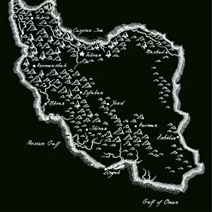
Metal Print : Ancient Iran map 1885


![]()
Metal Prints From Fine Art Storehouse
Ancient Iran map 1885
Encyclopedia Britannica 9th Edition New York Charles Scribners and Sons 1885 Vol XVIII
Unleash your creativity and transform your space into a visual masterpiece!
THEPALMER
Media ID 14756646
© This content is subject to copyright
16"x20" (51x41cm) Metal Print
Discover the rich history of Ancient Iran with our stunning Metal Print of the 1885 Ancient Iran Map by THEPALMER from the Media Storehouse Fine Art Collection. This exquisite piece, taken from the Encyclopedia Britannica 9th Edition published by Charles Scribners and Sons, New York, showcases intricate details of the geography and borders of Ancient Iran during that time. The high-quality metal print adds a modern and sophisticated touch while preserving the historical essence of this captivating map. Bring a piece of the past into your home or office decor and ignite conversations with this unique and intriguing art piece.
Made with durable metal and luxurious printing techniques, our metal photo prints go beyond traditional canvases, adding a cool, modern touch to your space. Wall mount on back. Eco-friendly 100% post-consumer recycled ChromaLuxe aluminum surface. The thickness of the print is 0.045". Featuring a Scratch-resistant surface and Rounded corners. Backing hangers are attached to the back of the print and float the print 1/2-inch off the wall when hung, the choice of hanger may vary depending on size and International orders will come with Float Mount hangers only. Finished with a brilliant white high gloss surface for unsurpassed detail and vibrance. Printed using Dye-Sublimation and for best care we recommend a non-ammonia glass cleaner, water, or isopropyl (rubbing) alcohol to prevent harming the print surface. We recommend using a clean, lint-free cloth to wipe off the print. The ultra-hard surface is scratch-resistant, waterproof and weatherproof. Avoid direct sunlight exposure.
Made with durable metal and luxurious printing techniques, metal prints bring images to life and add a modern touch to any space
Estimated Image Size (if not cropped) is 50.8cm x 40.6cm (20" x 16")
Estimated Product Size is 51.4cm x 41.2cm (20.2" x 16.2")
These are individually made so all sizes are approximate
Artwork printed orientated as per the preview above, with landscape (horizontal) orientation to match the source image.
FEATURES IN THESE COLLECTIONS
> Fine Art Storehouse
> Map
> Historical Maps
> Asia
> Iran
> Related Images
> Maps and Charts
> Early Maps
> Maps and Charts
> Related Images
> North America
> United States of America
> New York
> New York
> Maps
> North America
> United States of America
> New York
> Related Images
EDITORS COMMENTS
This print titled "Ancient Iran map 1885" takes us on a mesmerizing journey through time, transporting us back to the rich and storied history of Persia. Captured from an original source in the Encyclopedia Britannica's 9th Edition, published by Charles Scribners and Sons in New York in 1885, this remarkable piece of art offers a glimpse into the ancient world. The intricate details of this map are truly awe-inspiring. Every line and curve meticulously drawn with precision, it showcases the vast expanse of what was once known as Persia. From its western borders stretching towards Mesopotamia to its eastern reaches touching India, this map encapsulates the grandeur and significance of Ancient Iran. As we explore this historical artifact further, we uncover layers upon layers of cultural heritage etched onto its surface. The names of long-forgotten cities come alive again - Persepolis, Susa, Ecbatana - reminding us that these lands were once home to great civilizations that shaped human history. "The Palmer" whose name is attributed to this stunning artwork from Fine Art Storehouse, has masterfully preserved not just a geographical representation but also a tangible connection to our past. This photograph print serves as both an educational tool for scholars and an exquisite decorative piece for enthusiasts who appreciate the beauty found within antiquity. With each glance at "Ancient Iran map 1885" we are transported back centuries ago when empires rose and fell
MADE IN THE USA
Safe Shipping with 30 Day Money Back Guarantee
FREE PERSONALISATION*
We are proud to offer a range of customisation features including Personalised Captions, Color Filters and Picture Zoom Tools
SECURE PAYMENTS
We happily accept a wide range of payment options so you can pay for the things you need in the way that is most convenient for you
* Options may vary by product and licensing agreement. Zoomed Pictures can be adjusted in the Basket.