Metal Print > Europe > United Kingdom > Northern Ireland > Maps
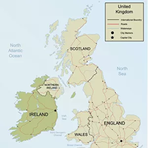
Metal Print : UK map


![]()
Metal Prints From Fine Art Storehouse
UK map
Unleash your creativity and transform your space into a visual masterpiece!
Media ID 14637307
16"x20" (51x41cm) Metal Print
Made with durable metal and luxurious printing techniques, our metal photo prints go beyond traditional canvases, adding a cool, modern touch to your space. Wall mount on back. Eco-friendly 100% post-consumer recycled ChromaLuxe aluminum surface. The thickness of the print is 0.045". Featuring a Scratch-resistant surface and Rounded corners. Backing hangers are attached to the back of the print and float the print 1/2-inch off the wall when hung, the choice of hanger may vary depending on size and International orders will come with Float Mount hangers only. Finished with a brilliant white high gloss surface for unsurpassed detail and vibrance. Printed using Dye-Sublimation and for best care we recommend a non-ammonia glass cleaner, water, or isopropyl (rubbing) alcohol to prevent harming the print surface. We recommend using a clean, lint-free cloth to wipe off the print. The ultra-hard surface is scratch-resistant, waterproof and weatherproof. Avoid direct sunlight exposure.
Made with durable metal and luxurious printing techniques, metal prints bring images to life and add a modern touch to any space
Estimated Image Size (if not cropped) is 40.6cm x 50.8cm (16" x 20")
Estimated Product Size is 41.2cm x 51.4cm (16.2" x 20.2")
These are individually made so all sizes are approximate
Artwork printed orientated as per the preview above, with portrait (vertical) orientation to match the source image.
FEATURES IN THESE COLLECTIONS
> Fine Art Storehouse
> Map
> Cartoon Maps
> Arts
> Artists
> O
> Oceanic Oceanic
> Arts
> Minimalist artwork
> Minimalist art
> Minimalist paintings
> Arts
> Minimalist artwork
> Minimalist art
> Europe
> Republic of Ireland
> Maps
> Europe
> United Kingdom
> England
> Maps
> Europe
> United Kingdom
> England
> Politics
> Europe
> United Kingdom
> Maps
> Europe
> United Kingdom
> Northern Ireland
> Maps
> Europe
> United Kingdom
> Northern Ireland
> Politics
VISUAL DESCRIPTION
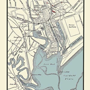
The image presents a simplified political map of the United Kingdom with England, Scotland, Ireland (Northern Ireland being part of the UK), and Wales clearly delineated in different shades of green. Major cities are marked by name for easy identification. The surrounding waters—the North Atlantic Ocean on one side and English Channel on another—frame these nations while emphasizing their geographic positions within Europe. Notably absent are intricate details like smaller towns or topographical variations; instead, this minimalist approach focuses on providing a clear understanding of national boundaries and major urban centers against a backdrop of international context.
MADE IN THE USA
Safe Shipping with 30 Day Money Back Guarantee
FREE PERSONALISATION*
We are proud to offer a range of customisation features including Personalised Captions, Color Filters and Picture Zoom Tools
SECURE PAYMENTS
We happily accept a wide range of payment options so you can pay for the things you need in the way that is most convenient for you
* Options may vary by product and licensing agreement. Zoomed Pictures can be adjusted in the Basket.