Metal Print > Europe > United Kingdom > England > London > Museums > National Maritime Museum
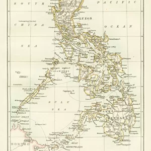
Metal Print : A chart of the channel in the Phillippine Islands through which the Manila Galeon passes together with the adjacent islands, 1748 (engraving)
")

![]()
Metal Prints From Fine Art Finder
A chart of the channel in the Phillippine Islands through which the Manila Galeon passes together with the adjacent islands, 1748 (engraving)
7339387 A chart of the channel in the Phillippine Islands through which the Manila Galeon passes together with the adjacent islands, 1748 (engraving) by Seale, Richard William (fl.1732-75); 75.5x55.5 cm; National Maritime Museum, London, UK; (add.info.: Creator: RW Seale
Single sheet. Engr. Scale: [ca.1:1 500 000]. Cartographic Note: Border graduated for latitude. Rhumb lines. Additional Places: Luzon. In June 1743 Anson redeemed his disastrous voyage by capturing the Acapulco treasure galleon as it sailed in to Manila. He lay in wait at Capo de Espiritu Santo.); © National Maritime Museum, Greenwich, London
Media ID 38339578
© © National Maritime Museum, Greenwich, London / Bridgeman Images
Filipino Islands Isles Philippines Phillippine South East Asia Asiae
16"x20" (51x41cm) Metal Print
Step back in time and explore the rich history of navigation with our Metal Prints from Media Storehouse. This stunning piece, 'A chart of the channel in the Phillippine Islands through which the Manila Galeon passes together with the adjacent islands, 1748 (engraving)', by Bridgeman Images from Fine Art Finder, brings to life a vintage map that once guided sailors and traders along their journeys. With its intricate details and nostalgic charm, this metal print is sure to be a treasured addition to any room.
Made with durable metal and luxurious printing techniques, our metal photo prints go beyond traditional canvases, adding a cool, modern touch to your space. Wall mount on back. Eco-friendly 100% post-consumer recycled ChromaLuxe aluminum surface. The thickness of the print is 0.045". Featuring a Scratch-resistant surface and Rounded corners. Backing hangers are attached to the back of the print and float the print 1/2-inch off the wall when hung, the choice of hanger may vary depending on size and International orders will come with Float Mount hangers only. Finished with a brilliant white high gloss surface for unsurpassed detail and vibrance. Printed using Dye-Sublimation and for best care we recommend a non-ammonia glass cleaner, water, or isopropyl (rubbing) alcohol to prevent harming the print surface. We recommend using a clean, lint-free cloth to wipe off the print. The ultra-hard surface is scratch-resistant, waterproof and weatherproof. Avoid direct sunlight exposure.
Made with durable metal and luxurious printing techniques, metal prints bring images to life and add a modern touch to any space
Estimated Image Size (if not cropped) is 40.6cm x 50.8cm (16" x 20")
Estimated Product Size is 41.2cm x 51.4cm (16.2" x 20.2")
These are individually made so all sizes are approximate
Artwork printed orientated as per the preview above, with portrait (vertical) orientation to match the source image.
FEATURES IN THESE COLLECTIONS
> Fine Art Finder
> Artists
> Richard William Seale
> Fine Art Finder
> Artists
> Unknown Artist
> Animals
> Insects
> Hemiptera
> Black Scale
> Arts
> Artists
> W
> William White
> Asia
> Philippines
> Manila
> Asia
> Philippines
> Maps
> Asia
> Philippines
> Related Images
> Europe
> United Kingdom
> England
> London
> Boroughs
> Greenwich
> Europe
> United Kingdom
> England
> London
> Museums
> Greenwich Heritage Centre
> Europe
> United Kingdom
> England
> London
> Museums
> National Maritime Museum
> Europe
> United Kingdom
> England
> London
> Towns
> Greenwich
> Europe
> United Kingdom
> Heritage Sites
> Maritime Greenwich
EDITORS COMMENTS
This stunning engraving from 1748 depicts a chart of the channel in the Philippine Islands through which the Manila Galeon passes, along with the adjacent islands. Created by Richard William Seale, this intricate map showcases the detailed cartography and navigational aids used during that time period.
The border of the map is graduated for latitude, with rhumb lines indicating direction for sailors. The main focus is on Luzon, one of the largest islands in the Philippines. In June 1743, Admiral Anson made history by capturing the Acapulco treasure galleon as it sailed into Manila while waiting at Capo de Espiritu Santo.
This historical piece provides a glimpse into early 18th-century navigation and exploration in Asia. The black-and-white engraving captures not only geographical information but also reflects the artistry and skill of its creator.
Displayed at the National Maritime Museum in London, this print serves as a reminder of a bygone era when seafaring was both treacherous and adventurous. It stands as a testament to human ingenuity and perseverance in mapping out uncharted territories and navigating through unknown waters.
MADE IN THE USA
Safe Shipping with 30 Day Money Back Guarantee
FREE PERSONALISATION*
We are proud to offer a range of customisation features including Personalised Captions, Color Filters and Picture Zoom Tools
SECURE PAYMENTS
We happily accept a wide range of payment options so you can pay for the things you need in the way that is most convenient for you
* Options may vary by product and licensing agreement. Zoomed Pictures can be adjusted in the Basket.