Metal Print > Arts > Artists > C > Catalan School Catalan School
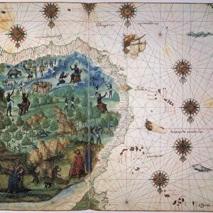
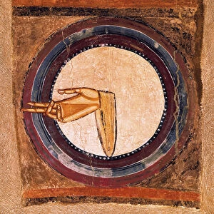
Metal Print : World Map of Catalan origin - 15th century


![]()
Metal Prints From Fine Art Finder
World Map of Catalan origin - 15th century
GIA4812920 World Map of Catalan origin - 15th century by Spanish School, (15th century); Biblioteca Nazionale Marciana, Venice, Italy; (add.info.: World Map of Catalan origin - 15th century); eGiancarlo Costa; Spanish, out of copyright
Media ID 22827950
© Giancarlo Costa / Bridgeman Images
Circle Planisphere Geographical Map
20"x24" (61x51cm) Metal Print
Discover the rich history of cartography with our exquisite Metal Print of a World Map from the 15th century. This stunning piece, copyrighted by Giancarlo Costa from Fine Art Finder (GIA4812920), showcases a Catalan origin World Map from the Spanish School. Meticulously preserved in the Biblioteca Nazionale Marciana, Venice, this captivating map transports you back in time, offering a unique perspective of the world as it was known during the Renaissance era. Our high-quality Metal Prints bring the intricate details and vibrant colors of this precious artifact to life, making it a beautiful addition to any home or office decor. Experience the fusion of history and art with our Metal Print of the Catalan Origin World Map.
Made with durable metal and luxurious printing techniques, our metal photo prints go beyond traditional canvases, adding a cool, modern touch to your space. Wall mount on back. Eco-friendly 100% post-consumer recycled ChromaLuxe aluminum surface. The thickness of the print is 0.045". Featuring a Scratch-resistant surface and Rounded corners. Backing hangers are attached to the back of the print and float the print 1/2-inch off the wall when hung, the choice of hanger may vary depending on size and International orders will come with Float Mount hangers only. Finished with a brilliant white high gloss surface for unsurpassed detail and vibrance. Printed using Dye-Sublimation and for best care we recommend a non-ammonia glass cleaner, water, or isopropyl (rubbing) alcohol to prevent harming the print surface. We recommend using a clean, lint-free cloth to wipe off the print. The ultra-hard surface is scratch-resistant, waterproof and weatherproof. Avoid direct sunlight exposure.
Made with durable metal and luxurious printing techniques, metal prints bring images to life and add a modern touch to any space
Estimated Image Size (if not cropped) is 60.9cm x 50.8cm (24" x 20")
Estimated Product Size is 61.5cm x 51.4cm (24.2" x 20.2")
These are individually made so all sizes are approximate
Artwork printed orientated as per the preview above, with landscape (horizontal) orientation to match the source image.
FEATURES IN THESE COLLECTIONS
> Arts
> Artists
> C
> Catalan School Catalan School
> Arts
> Artists
> I
> Italian School Italian School
> Arts
> Artists
> S
> Spanish School
> Europe
> Italy
> Veneto
> Venice
> Maps and Charts
> Italy
> Maps and Charts
> Related Images
> Maps and Charts
> Spain
EDITORS COMMENTS
This print showcases a remarkable piece of history - the World Map of Catalan origin from the 15th century. Created by an unknown Spanish artist, this manuscript is currently housed in the Biblioteca Nazionale Marciana in Venice, Italy. The map itself is a true testament to the artistry and skill of its creator. It features intricate illuminations and miniatures that bring to life the geographical wonders of our planet during the Middle Ages. The circular planisphere presents a comprehensive view of the world as it was understood at that time. As we gaze upon this ancient cartographic masterpiece, we are transported back in time to an era when exploration and discovery were at their peak. Each meticulously drawn detail tells a story of brave explorers venturing into uncharted territories, seeking new lands and treasures. This particular print has been expertly captured by Giancarlo Costa, allowing us to appreciate every delicate stroke and vibrant color used in its creation. As we study this image, we can't help but marvel at how far our understanding of geography has come since then. Whether you're a history enthusiast or simply captivated by beautiful works of art, this World Map offers both historical significance and aesthetic pleasure. Let it serve as a reminder that even centuries-old manuscripts continue to inspire wonder and curiosity within us all.
MADE IN THE USA
Safe Shipping with 30 Day Money Back Guarantee
FREE PERSONALISATION*
We are proud to offer a range of customisation features including Personalised Captions, Color Filters and Picture Zoom Tools
SECURE PAYMENTS
We happily accept a wide range of payment options so you can pay for the things you need in the way that is most convenient for you
* Options may vary by product and licensing agreement. Zoomed Pictures can be adjusted in the Basket.