Metal Print > Animals > Mammals > Muridae > Water Mouse
Metal Print : Map of North America (Greenland, Canada, USA, Mexico and the Caribbean Islands: Cuba


![]()
Metal Prints From Fine Art Finder
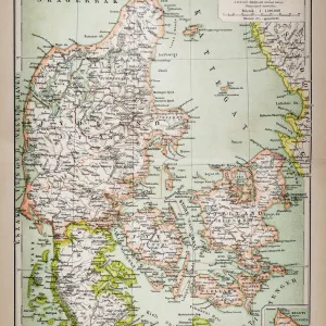
Map of North America (Greenland, Canada, USA, Mexico and the Caribbean Islands: Cuba
LRI4706891 Map of North America (Greenland, Canada, USA, Mexico and the Caribbean Islands: Cuba, Haiti, Jamaica, West Indies) (etching, 1730) by Delisle, Guillaume (1675-1726); Private Collection; (add.info.: Map of North America (Greenland, Canada, USA, Mexico and the Caribbean Islands: Cuba, Haiti, Jamaica, West Indies) - Strong water extracted from the " New Atlas containing all parts of the world" 1730 by Guillaume de L Isle (1675-1726)); Luisa Ricciarini; French, out of copyright
Media ID 23718162
© Luisa Ricciarini / Bridgeman Images
Atlas Book Caribbean Central America Cuba Cuban Danish Danish Women Denmark Greenland Haiti Jamaica Jamaican Nordic Countries America Continent Canadians Geographical Map
16"x20" (51x41cm) Metal Print
Discover the beauty of historical cartography with our Media Storehouse Metal Print of a vintage map of North America. This exquisite piece, featuring the intricate detail of a 1730 etching by Delisle, showcases the early exploration of Greenland, Canada, the United States, Mexico, and the Caribbean Islands, including Cuba, Haiti, Jamaica, and the West Indies. Luisa Ricciarini's fine art reproduction from Fine Art Finder transports you back in time, making it a unique and captivating addition to any home or office decor. The high-quality metal print offers vivid colors, exceptional clarity, and a sleek, modern look that is sure to impress.
Made with durable metal and luxurious printing techniques, our metal photo prints go beyond traditional canvases, adding a cool, modern touch to your space. Wall mount on back. Eco-friendly 100% post-consumer recycled ChromaLuxe aluminum surface. The thickness of the print is 0.045". Featuring a Scratch-resistant surface and Rounded corners. Backing hangers are attached to the back of the print and float the print 1/2-inch off the wall when hung, the choice of hanger may vary depending on size and International orders will come with Float Mount hangers only. Finished with a brilliant white high gloss surface for unsurpassed detail and vibrance. Printed using Dye-Sublimation and for best care we recommend a non-ammonia glass cleaner, water, or isopropyl (rubbing) alcohol to prevent harming the print surface. We recommend using a clean, lint-free cloth to wipe off the print. The ultra-hard surface is scratch-resistant, waterproof and weatherproof. Avoid direct sunlight exposure.
Made with durable metal and luxurious printing techniques, metal prints bring images to life and add a modern touch to any space
Estimated Image Size (if not cropped) is 50.8cm x 40.6cm (20" x 16")
Estimated Product Size is 51.4cm x 41.2cm (20.2" x 16.2")
These are individually made so all sizes are approximate
Artwork printed orientated as per the preview above, with landscape (horizontal) orientation to match the source image.
FEATURES IN THESE COLLECTIONS
> Animals
> Mammals
> Muridae
> Water Mouse
> Europe
> Denmark
> Related Images
> Europe
> United Kingdom
> Scotland
> Western Isles
> Related Images
> Maps and Charts
> Related Images
EDITORS COMMENTS
This print showcases a remarkable historical artifact - the "Map of North America (Greenland, Canada, USA, Mexico and the Caribbean Islands: Cuba, Haiti, Jamaica, West Indies)" by Guillaume de L'Isle. Created in 1730 and extracted from the renowned "New Atlas containing all parts of the world" this etching offers a glimpse into the geographical understanding of that era. The map encompasses an extensive area spanning Greenland to Mexico and includes notable countries like Canada, USA, Cuba, Haiti, Jamaica, and various islands within the West Indies. Its intricate details provide valuable insights into the geography of North America during the 18th century. Guillaume de L'Isle's expertise as a cartographer is evident in this masterpiece. The precision with which he delineates coastlines and accurately positions each country demonstrates his commitment to accuracy in mapping. This particular print has been preserved in a private collection for generations. Luisa Ricciarini expertly captures this historical treasure through her lens. Her careful attention to detail allows viewers to appreciate not only the artistic beauty but also its educational significance. As we gaze upon this image today, we are transported back in time to an era when exploration was at its peak and our understanding of North America was expanding rapidly. This photograph serves as a reminder of how far we have come in terms of geographic knowledge while honoring those who paved the way for our current understanding of these lands.
MADE IN THE USA
Safe Shipping with 30 Day Money Back Guarantee
FREE PERSONALISATION*
We are proud to offer a range of customisation features including Personalised Captions, Color Filters and Picture Zoom Tools
SECURE PAYMENTS
We happily accept a wide range of payment options so you can pay for the things you need in the way that is most convenient for you
* Options may vary by product and licensing agreement. Zoomed Pictures can be adjusted in the Basket.