Metal Print > Arts > Artists > B > Willem Blaeu
Metal Print : Geographic map of America. In "Le theatre du monde ou le nouvel atlas


![]()
Metal Prints from Fine Art Finder
Geographic map of America. In "Le theatre du monde ou le nouvel atlas
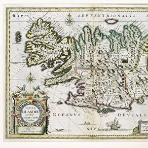
JLJ4690395 Geographic map of America. In " Le theatre du monde ou le nouvel atlas Amsterdam" produced by Willem Janszoon Blaeu (1571-1638), 1635. Paris, NL by Blaeu, Willem (1571-1638); Bibliotheque Nationale, Paris, France; (add.info.: Geographic map of America. In " Le theatre du monde ou le nouvel atlas Amsterdam" produced by Willem Janszoon Blaeu (1571-1638), 1635. Paris, NL); Photo ePhoto Josse; Dutch, out of copyright
Media ID 23736052
© Josse / Bridgeman Images
Central America Planisphere Geographical Map
16"x20" (51x41cm) Metal Print
Discover the beauty of the American continent with our stunning Metal Print of the Geographic map of America, taken from the renowned atlas "Le theatre du monde ou le nouvel atlas" by Willem Janszoon Blaeu, published in Amsterdam in 1635. This exquisite map, featuring the captivating image by Photo Josse from Fine Art Finder (JLJ4690395), is meticulously printed on high-quality metal, ensuring vibrant colors and exceptional durability. Bring a piece of historical cartography into your home or office and transport yourself on a journey across the vast landscapes of the Americas. Each Metal Print is individually crafted with care and comes ready to hang, making it a unique and eye-catching addition to any space.
Made with durable metal and luxurious printing techniques, our metal photo prints go beyond traditional canvases, adding a cool, modern touch to your space. Wall mount on back. Eco-friendly 100% post-consumer recycled ChromaLuxe aluminum surface. The thickness of the print is 0.045". Featuring a Scratch-resistant surface and Rounded corners. Backing hangers are attached to the back of the print and float the print 1/2-inch off the wall when hung, the choice of hanger may vary depending on size and International orders will come with Float Mount hangers only. Finished with a brilliant white high gloss surface for unsurpassed detail and vibrance. Printed using Dye-Sublimation and for best care we recommend a non-ammonia glass cleaner, water, or isopropyl (rubbing) alcohol to prevent harming the print surface. We recommend using a clean, lint-free cloth to wipe off the print. The ultra-hard surface is scratch-resistant, waterproof and weatherproof. Avoid direct sunlight exposure.
Made with durable metal and luxurious printing techniques, metal prints bring images to life and add a modern touch to any space
Estimated Image Size (if not cropped) is 50.8cm x 40.6cm (20" x 16")
Estimated Product Size is 51.4cm x 41.2cm (20.2" x 16.2")
These are individually made so all sizes are approximate
Artwork printed orientated as per the preview above, with landscape (horizontal) orientation to match the source image.
FEATURES IN THESE COLLECTIONS
> Fine Art Finder
> Artists
> Filippo Brunelleschi
> Fine Art Finder
> Artists
> Willem Blaeu
> Arts
> Artists
> B
> Willem Blaeu
> Europe
> France
> Paris
> Maps
> Europe
> France
> Paris
> Related Images
> Maps and Charts
> Related Images
> Maps and Charts
> Willem Janszoon Blaeu
> Maps and Charts
> World
> North America
> Related Images
> South America
> Related Images
EDITORS COMMENTS
This print showcases a historical geographic map of America, taken from the renowned work "Le theatre du monde ou le nouvel atlas Amsterdam" produced by Willem Janszoon Blaeu in 1635. The map, now housed at Bibliotheque Nationale in Paris, France, offers a fascinating glimpse into the world as it was perceived during the 17th century. The intricate engraving depicts not only North and South America but also Central America, presenting a comprehensive planisphere that highlights the borders and geographical features of these continents. It is an invaluable resource for studying the evolution of cartography and understanding how early explorers envisioned this vast landmass. Willem Janszoon Blaeu's meticulous attention to detail is evident in every line and curve on this map. From mountain ranges to rivers and coastlines, each element has been carefully rendered to provide an accurate representation of America's geography at that time. As we gaze upon this remarkable piece of history through Photo Josse's lens, we are transported back in time to an era when exploration was still unfolding. This print serves as a reminder of our ever-evolving understanding of the world around us and invites us to appreciate both the artistry and scientific significance behind ancient maps like these.
MADE IN THE USA
Safe Shipping with 30 Day Money Back Guarantee
FREE PERSONALISATION*
We are proud to offer a range of customisation features including Personalised Captions, Color Filters and Picture Zoom Tools
SECURE PAYMENTS
We happily accept a wide range of payment options so you can pay for the things you need in the way that is most convenient for you
* Options may vary by product and licensing agreement. Zoomed Pictures can be adjusted in the Cart.