Metal Print > Europe > United Kingdom > England > London > Museums > National Army Museum
Metal Print : Three printed coloured maps: Fairburns New Chart Exhibiting the Route of General


![]()
Metal Prints from Fine Art Finder
Three printed coloured maps: Fairburns New Chart Exhibiting the Route of General
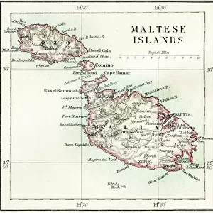
3062961 Three printed coloured maps: Fairburns New Chart Exhibiting the Route of General Bonaparte in the Mediterranean Sea, 1798 (engraving) by English School, (18th century); National Army Museum, London; (add.info.: With the Countries through which the French Army must pass, viz Egypt and the Red Sea; or the Gulf of Persia, & to Mangalore in the Territory of Tippoo Sahib, in the East Indies. To which is annexed A Particular Plan of the Island and Harbour of Malta.
Published 13 Aug 1798.
Associated with the Wars of the French Revolution, Egypt (1799-1801).); eNational Army Museum; English, out of copyright
Media ID 23115082
© National Army Museum / Bridgeman Images
Islands Malta Mediterranean Sea Napoleon Bonaparte General Bonaparte Gulf Of Persia
16"x24" (61x41cm) Metal Print
Discover history in vibrant detail with Media Storehouse's Metal Prints featuring three beautifully colored maps from Bridgeman Images. This collection showcases Fairburns New Chart Exhibiting the Route of General Bonaparte in the Mediterranean Sea, an 18th-century engraving from the National Army Museum. Each map is meticulously printed onto high-quality metal, ensuring lasting brilliance and a distinctive, modern look. Bring history into your home or office with these captivating and conversation-starting decor pieces.
Made with durable metal and luxurious printing techniques, our metal photo prints go beyond traditional canvases, adding a cool, modern touch to your space. Wall mount on back. Eco-friendly 100% post-consumer recycled ChromaLuxe aluminum surface. The thickness of the print is 0.045". Featuring a Scratch-resistant surface and Rounded corners. Backing hangers are attached to the back of the print and float the print 1/2-inch off the wall when hung, the choice of hanger may vary depending on size and International orders will come with Float Mount hangers only. Finished with a brilliant white high gloss surface for unsurpassed detail and vibrance. Printed using Dye-Sublimation and for best care we recommend a non-ammonia glass cleaner, water, or isopropyl (rubbing) alcohol to prevent harming the print surface. We recommend using a clean, lint-free cloth to wipe off the print. The ultra-hard surface is scratch-resistant, waterproof and weatherproof. Avoid direct sunlight exposure.
Made with durable metal and luxurious printing techniques, metal prints bring images to life and add a modern touch to any space
Estimated Product Size is 61.5cm x 41.2cm (24.2" x 16.2")
These are individually made so all sizes are approximate
Artwork printed orientated as per the preview above, with landscape (horizontal) orientation to match the source image.
FEATURES IN THESE COLLECTIONS
> Fine Art Finder
> Artists
> English School
> Fine Art Finder
> Maps (celestial & Terrestrial)
> Africa
> Egypt
> Related Images
> Europe
> Malta
> Related Images
> Europe
> United Kingdom
> England
> London
> Museums
> National Army Museum
EDITORS COMMENTS
This print showcases three beautifully colored maps titled "Fairburns New Chart Exhibiting the Route of General Bonaparte in the Mediterranean Sea, 1798". Created by an anonymous English School artist from the 18th century, these maps are housed at the National Army Museum in London. The intricate engravings depict various regions and countries that were significant during the time of Napoleon Bonaparte's military campaign. The first map highlights Egypt and the Red Sea, illustrating the path taken by the French Army. The second map extends to Mangalore in Tippoo Sahib's territory in East Indies, showcasing its strategic importance. Lastly, a detailed plan of Malta and its harbor is annexed to provide a comprehensive view. Published on August 13th, 1798, these maps hold historical significance as they are associated with the Wars of the French Revolution and specifically with Napoleon's expedition to Egypt between 1799-1801. They offer valuable insights into European expansionism during this era. Preserved by eNational Army Museum and made available through Bridgeman Images' collection on Fine Art Finder platform, this print allows viewers to delve into an important chapter of world history. With their vibrant colors and meticulous details, these maps serve as both educational tools for understanding past events and stunning pieces of art capturing cartographic excellence.
MADE IN THE USA
Safe Shipping with 30 Day Money Back Guarantee
FREE PERSONALISATION*
We are proud to offer a range of customisation features including Personalised Captions, Color Filters and Picture Zoom Tools
SECURE PAYMENTS
We happily accept a wide range of payment options so you can pay for the things you need in the way that is most convenient for you
* Options may vary by product and licensing agreement. Zoomed Pictures can be adjusted in the Cart.