Metal Print > Fine Art Finder > Artists > Charles Marie Rigobert Bonne
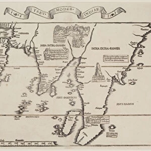
Metal Print : France by Regions, from Atlas de Toutes les Parties Connues du Globe Terrestre


Please select a smaller print size for this image
![]()
Metal Prints from Fine Art Finder
France by Regions, from Atlas de Toutes les Parties Connues du Globe Terrestre
KW206608 France by Regions, from Atlas de Toutes les Parties Connues du Globe Terrestre by Guillaume Raynal (1713-96) published 1780 (coloured engraving) by Bonne, Charles Marie Rigobert (1727-95); Private Collection; Ken Welsh; French, out of copyright
Media ID 12755753
© www.bridgemanimages.com
16"x24" (61x41cm) Metal Print
Discover the timeless beauty of France with our Media Storehouse Metal Prints featuring the enchanting map, "France by Regions," from the Atlas de Toutes les Parties Connues du Globe Terrestre by Guillaume Raynal. Published in 1780, this exquisite coloured engraving by Bonne captures the essence of France's rich history and diverse regions. Our high-quality metal prints offer vibrant colours, stunning detail, and a contemporary twist, making this historic map a captivating addition to any home or office space. Bring a piece of the past into your present with Media Storehouse Metal Prints.
Made with durable metal and luxurious printing techniques, our metal photo prints go beyond traditional canvases, adding a cool, modern touch to your space. Wall mount on back. Eco-friendly 100% post-consumer recycled ChromaLuxe aluminum surface. The thickness of the print is 0.045". Featuring a Scratch-resistant surface and Rounded corners. Backing hangers are attached to the back of the print and float the print 1/2-inch off the wall when hung, the choice of hanger may vary depending on size and International orders will come with Float Mount hangers only. Finished with a brilliant white high gloss surface for unsurpassed detail and vibrance. Printed using Dye-Sublimation and for best care we recommend a non-ammonia glass cleaner, water, or isopropyl (rubbing) alcohol to prevent harming the print surface. We recommend using a clean, lint-free cloth to wipe off the print. The ultra-hard surface is scratch-resistant, waterproof and weatherproof. Avoid direct sunlight exposure.
Made with durable metal and luxurious printing techniques, metal prints bring images to life and add a modern touch to any space
Estimated Product Size is 61.5cm x 41.2cm (24.2" x 16.2")
These are individually made so all sizes are approximate
Artwork printed orientated as per the preview above, with landscape (horizontal) orientation to match the source image.
EDITORS COMMENTS
This print showcases the intricate details of "France by Regions" from the renowned Atlas de Toutes les Parties Connues du Globe Terrestre. Created by Guillaume Raynal and published in 1780, this coloured engraving offers a glimpse into the geographical divisions of France during that era. The artist behind this masterpiece is Charles Marie Rigobert Bonne, whose exceptional talent shines through in every stroke. The map takes us on a visual journey across France's diverse regions, each marked with precision and elegance. From the rugged coastlines of Brittany to the rolling hills of Provence, this print captures the essence and beauty of each area. The vibrant colors bring life to the landscapes, evoking a sense of awe and wonder. As we gaze upon this historic piece, we are transported back in time to an era when cartography was both artistry and science. It serves as a reminder of how far we have come in our understanding and exploration of our planet. This print is part of a private collection curated by Ken Welsh, who has dedicated his passion for fine art to preserve these timeless treasures for future generations. Through www. bridgemanimages. com, we can now appreciate and admire these works from the comfort of our own homes. Whether you are an avid history enthusiast or simply captivated by beautiful artwork, this print is sure to be a cherished addition to any collection.
MADE IN THE USA
Safe Shipping with 30 Day Money Back Guarantee
FREE PERSONALISATION*
We are proud to offer a range of customisation features including Personalised Captions, Color Filters and Picture Zoom Tools
SECURE PAYMENTS
We happily accept a wide range of payment options so you can pay for the things you need in the way that is most convenient for you
* Options may vary by product and licensing agreement. Zoomed Pictures can be adjusted in the Cart.