Metal Print > Arts > Artists > A > Battista Agnese
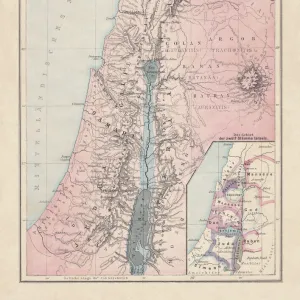
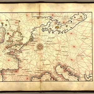
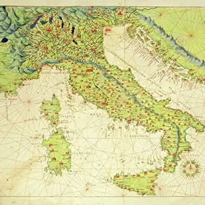
Metal Print : The Sea of Galilee, from an Atlas of the World in 33 Maps, Venice, 1st September 1553


![]()
Metal Prints From Fine Art Finder
The Sea of Galilee, from an Atlas of the World in 33 Maps, Venice, 1st September 1553
XOT330965 The Sea of Galilee, from an Atlas of the World in 33 Maps, Venice, 1st September 1553 (ink on vellum) (detail from 330966) by Agnese, Battista (1514-64); Museo Correr, Venice, Italy; Italian, out of copyright
Media ID 18255165
© Museo Correr, Venice, Italy / Bridgeman Images
Canaan Holy Land Israel Lakes Mapping Mare Nazareth River Jordan Tiberias
16"x20" (51x41cm) Metal Print
Discover the rich history of cartography with our Media Storehouse Metal Print of The Sea of Galilee, taken from an exquisite 16th-century map. Hailing from the Atlas of the World in 33 Maps, published in Venice on 1st September 1553, this intricately detailed map is a captivating glimpse into the past. Created by the skilled Venetian cartographer Battista Agnese, this masterpiece is now available as a stunning metal print, bringing the history and beauty of cartography into your home or office. With Bridgeman Images and Fine Art Finder, you can own a piece of history that tells a story of exploration, discovery, and the ever-evolving understanding of our world.
Made with durable metal and luxurious printing techniques, our metal photo prints go beyond traditional canvases, adding a cool, modern touch to your space. Wall mount on back. Eco-friendly 100% post-consumer recycled ChromaLuxe aluminum surface. The thickness of the print is 0.045". Featuring a Scratch-resistant surface and Rounded corners. Backing hangers are attached to the back of the print and float the print 1/2-inch off the wall when hung, the choice of hanger may vary depending on size and International orders will come with Float Mount hangers only. Finished with a brilliant white high gloss surface for unsurpassed detail and vibrance. Printed using Dye-Sublimation and for best care we recommend a non-ammonia glass cleaner, water, or isopropyl (rubbing) alcohol to prevent harming the print surface. We recommend using a clean, lint-free cloth to wipe off the print. The ultra-hard surface is scratch-resistant, waterproof and weatherproof. Avoid direct sunlight exposure.
Made with durable metal and luxurious printing techniques, metal prints bring images to life and add a modern touch to any space
Estimated Image Size (if not cropped) is 50.8cm x 40.6cm (20" x 16")
Estimated Product Size is 51.4cm x 41.2cm (20.2" x 16.2")
These are individually made so all sizes are approximate
Artwork printed orientated as per the preview above, with landscape (horizontal) orientation to match the source image.
FEATURES IN THESE COLLECTIONS
> Fine Art Finder
> Artists
> Battista Agnese
> Fine Art Finder
> Maps (celestial & Terrestrial)
> Arts
> Artists
> A
> Battista Agnese
> Arts
> Landscape paintings
> Waterfall and river artworks
> River artworks
> Asia
> Israel
> Lakes
> Related Images
> Asia
> Israel
> Lakes
> Sea of Galilee
> Asia
> Israel
> Related Images
> Asia
> Jordan
> Lakes
> Related Images
> Europe
> France
> Canton
> Landes
> Europe
> Italy
> Lakes
> Related Images
EDITORS COMMENTS
This print showcases a detailed map titled "The Sea of Galilee" from an Atlas of the World in 33 Maps, created by Battista Agnese on September 1st, 1553. The image is a close-up view of this remarkable piece, which was crafted using ink on vellum and is currently housed in the Museo Correr in Venice, Italy. The map depicts the famous biblical body of water known as the Sea of Galilee or Lake Tiberias. It beautifully captures the essence and significance of this holy site located in Israel's historic region, Canaan. The intricate details highlight not only the lake itself but also its surrounding areas such as Nazareth and Tiberias. Through this artwork, Agnese skillfully combines cartography with artistic flair to create a visually stunning representation. Every stroke reveals his meticulous craftsmanship and dedication to accuracy. This particular map holds immense historical value as it provides insight into how people perceived geography during that period. As we gaze upon this extraordinary print, we are transported back in time to witness how ancient civilizations navigated these waters and explored their surroundings. It serves as a testament to human curiosity and our eternal quest for knowledge about our world.
MADE IN THE USA
Safe Shipping with 30 Day Money Back Guarantee
FREE PERSONALISATION*
We are proud to offer a range of customisation features including Personalised Captions, Color Filters and Picture Zoom Tools
SECURE PAYMENTS
We happily accept a wide range of payment options so you can pay for the things you need in the way that is most convenient for you
* Options may vary by product and licensing agreement. Zoomed Pictures can be adjusted in the Basket.