Metal Print > Europe > United Kingdom > England > Related Images
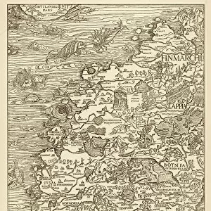
Metal Print : Northern Europe, from an Atlas of the World in 33 maps, Venice, 1st September 1553


![]()
Metal Prints From Fine Art Finder
Northern Europe, from an Atlas of the World in 33 maps, Venice, 1st September 1553
XOT330951 Northern Europe, from an Atlas of the World in 33 maps, Venice, 1st September 1553 (ink on vellum) (see also 330952) by Agnese, Battista (1514-64); 29x49 cm; Museo Correr, Venice, Italy; Italian, out of copyright
Media ID 12852670
© www.bridgemanart.com
Baltic Sea Chart Denmark Finland Iceland Mapping North Wind Norway Sea Monster Sweden
16"x20" (51x41cm) Metal Print
Transport yourself back in time with our stunning Metal Print of Northern Europe from the Atlas of the World in 33 Maps, published in Venice on 1st September 1553. This intricately detailed map, created by Battista Agnese, showcases the geography of Northern Europe during the Renaissance era. Our high-quality Metal Print brings the beauty and history of this rare and valuable map to your home or office, with vibrant colors and sharp details that will captivate and inspire. Order now and add a touch of history and artistry to your space.
Made with durable metal and luxurious printing techniques, our metal photo prints go beyond traditional canvases, adding a cool, modern touch to your space. Wall mount on back. Eco-friendly 100% post-consumer recycled ChromaLuxe aluminum surface. The thickness of the print is 0.045". Featuring a Scratch-resistant surface and Rounded corners. Backing hangers are attached to the back of the print and float the print 1/2-inch off the wall when hung, the choice of hanger may vary depending on size and International orders will come with Float Mount hangers only. Finished with a brilliant white high gloss surface for unsurpassed detail and vibrance. Printed using Dye-Sublimation and for best care we recommend a non-ammonia glass cleaner, water, or isopropyl (rubbing) alcohol to prevent harming the print surface. We recommend using a clean, lint-free cloth to wipe off the print. The ultra-hard surface is scratch-resistant, waterproof and weatherproof. Avoid direct sunlight exposure.
Made with durable metal and luxurious printing techniques, metal prints bring images to life and add a modern touch to any space
Estimated Image Size (if not cropped) is 50.8cm x 40.6cm (20" x 16")
Estimated Product Size is 51.4cm x 41.2cm (20.2" x 16.2")
These are individually made so all sizes are approximate
Artwork printed orientated as per the preview above, with landscape (horizontal) orientation to match the source image.
FEATURES IN THESE COLLECTIONS
> Fine Art Finder
> Artists
> Battista Agnese
> Fine Art Finder
> Maps (celestial & Terrestrial)
> Europe
> Finland
> Related Images
> Europe
> Italy
> Related Images
> Europe
> United Kingdom
> England
> Related Images
> Europe
> United Kingdom
> Northern Ireland
> Related Images
EDITORS COMMENTS
This print showcases a remarkable piece of cartography from the 16th century. Created by Battista Agnese in Venice on September 1st, 1553, this ink on vellum map offers a glimpse into Northern Europe as it was known during that time. Measuring at 29x49 cm, this intricate map is housed in the Museo Correr in Venice, Italy. It depicts various countries and regions including Scandinavia, England, Ireland, Iceland, Finland, Sweden, Norway, Denmark and the Baltic Sea. The level of detail is astonishing; one can observe tiny boats sailing across the sea and even fish swimming beneath its surface. What makes this artwork truly fascinating are the mythical elements incorporated within it. A menacing sea monster lurks near Iceland while a personification of North Wind blows fiercely above Scandinavia. These fantastical additions add an air of mystery to an otherwise factual representation. Agnese's mastery shines through his precise rendering of coastlines and meticulous labeling of cities and towns throughout Northern Europe. This historical artifact not only serves as a valuable resource for understanding past geographical knowledge but also provides insight into Renaissance-era cartography techniques. This print allows us to appreciate both the artistic skill involved in creating such maps as well as gain insights into how our ancestors perceived their world centuries ago.
MADE IN THE USA
Safe Shipping with 30 Day Money Back Guarantee
FREE PERSONALISATION*
We are proud to offer a range of customisation features including Personalised Captions, Color Filters and Picture Zoom Tools
SECURE PAYMENTS
We happily accept a wide range of payment options so you can pay for the things you need in the way that is most convenient for you
* Options may vary by product and licensing agreement. Zoomed Pictures can be adjusted in the Basket.