Metal Print > Arts > Artists > O > Oceanic Oceanic
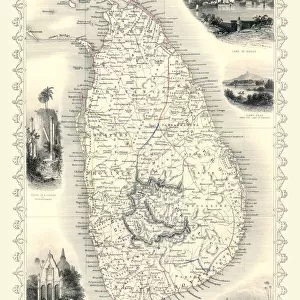
Metal Print : Map of Southern India and Ceylon, after a work made circa 1720 by Dutch cartographer


![]()
Metal Prints from Fine Art Finder
Map of Southern India and Ceylon, after a work made circa 1720 by Dutch cartographer
5892377 Map of Southern India and Ceylon, after a work made circa 1720 by Dutch cartographer Adriaan Reland (engraving) by Reland, Adriaan (1676-1718) (after); Private Collection; Dutch, out of copyright
Media ID 22587808
© Bridgeman Images
Archival Archive Ceylon Chart Countries Geographical Indian Ocean Islands Sri Lanka Tamil Nadu
16"x20" (51x41cm) Metal Print
Discover the rich history and cultural wonders of Southern India and Ceylon with our stunning Metal Print of this intricately detailed map. Originally created by Dutch cartographer Adriaan Reland around 1720, this captivating work showcases the vast expanse of the region as it was known during that time. The Map of Southern India and Ceylon, expertly reproduced from a rare and authentic engraving, is now available as a sleek and modern Metal Print. This premium print is not only a beautiful addition to any home or office decor, but also a unique and thoughtful gift for history enthusiasts or those with a connection to the region. Experience the allure of the past with our high-quality Metal Prints.
Made with durable metal and luxurious printing techniques, our metal photo prints go beyond traditional canvases, adding a cool, modern touch to your space. Wall mount on back. Eco-friendly 100% post-consumer recycled ChromaLuxe aluminum surface. The thickness of the print is 0.045". Featuring a Scratch-resistant surface and Rounded corners. Backing hangers are attached to the back of the print and float the print 1/2-inch off the wall when hung, the choice of hanger may vary depending on size and International orders will come with Float Mount hangers only. Finished with a brilliant white high gloss surface for unsurpassed detail and vibrance. Printed using Dye-Sublimation and for best care we recommend a non-ammonia glass cleaner, water, or isopropyl (rubbing) alcohol to prevent harming the print surface. We recommend using a clean, lint-free cloth to wipe off the print. The ultra-hard surface is scratch-resistant, waterproof and weatherproof. Avoid direct sunlight exposure.
Made with durable metal and luxurious printing techniques, metal prints bring images to life and add a modern touch to any space
Estimated Image Size (if not cropped) is 50.8cm x 40.6cm (20" x 16")
Estimated Product Size is 51.4cm x 41.2cm (20.2" x 16.2")
These are individually made so all sizes are approximate
Artwork printed orientated as per the preview above, with landscape (horizontal) orientation to match the source image.
FEATURES IN THESE COLLECTIONS
> Fine Art Finder
> Artists
> Antonio (after) Canaletto
> Arts
> Artists
> O
> Oceanic Oceanic
> Asia
> India
> Related Images
> Asia
> Sri Lanka
> Related Images
> Maps and Charts
> Early Maps
> Maps and Charts
> India
> Maps and Charts
> Related Images
EDITORS COMMENTS
This print showcases a remarkable piece of history - the "Map of Southern India and Ceylon" created by Dutch cartographer Adriaan Reland around 1720. The intricate details captured in this engraving transport us back to a time when exploration and discovery were at their peak. The map depicts the southern region of India, including the enchanting island of Ceylon (now known as Sri Lanka). It offers an invaluable glimpse into the geographical landscape, with its Indian Ocean backdrop and scattered islands dotting the vast expanse. Notably, it highlights Adam's Bridge, also known as Rama Setu or Ramas Bridge, connecting Tamil Nadu to Mannar Island across the Gulf of Mannar. As we delve into this historical archive, we are reminded of how maps have played an essential role in shaping our understanding of different countries and cultures throughout time. This particular map serves as a testament to Reland's expertise in charting unexplored territories during his era. With its aged appearance and delicate engravings, this 18th-century masterpiece transports us back to an era where cartography was both artistry and science. It invites us to appreciate not only the beauty but also the significance that lies within these ancient maps. Thanks to Fine Art Finder for preserving this valuable piece from a private collection. Through Ken Welsh's lens, we can now admire this stunning work while contemplating its rich historical context.
MADE IN THE USA
Safe Shipping with 30 Day Money Back Guarantee
FREE PERSONALISATION*
We are proud to offer a range of customisation features including Personalised Captions, Color Filters and Picture Zoom Tools
SECURE PAYMENTS
We happily accept a wide range of payment options so you can pay for the things you need in the way that is most convenient for you
* Options may vary by product and licensing agreement. Zoomed Pictures can be adjusted in the Cart.