Metal Print > Europe > France > Canton > Landes
Metal Print : Map of Holy land at the times of the First crusade (1096-1099) Engraving from Houze 1851 Private collection
 Engraving from Houze 1851 Private collection")

![]()
Metal Prints From Fine Art Finder
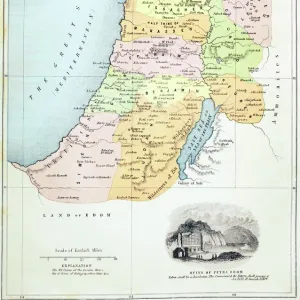
Map of Holy land at the times of the First crusade (1096-1099) Engraving from Houze 1851 Private collection
ELD4921914 Map of Holy land at the times of the First crusade (1096-1099) Engraving from Houze 1851 Private collection; (add.info.: Map of Holy land at the times of the First crusade (1096-1099) Engraving from Houze 1851 Private collection); Photo © The Holbarn Archive
Media ID 38418454
© © The Holbarn Archive / Bridgeman Images
1 1st I Ist Century 1 Century 11 11th 11th Xi 11th 11th Century 11 11th Xi Xith Century 11 Century 11th Century 1st 1st 1st Century 1st Century 1st Century Ad Crusade Eleventh Century First Century First Christian Century I Century Israel Israeli Ist Century Sec Xi Xi Century Xith Century Geographical Map Isadora
16"x20" (51x41cm) Metal Print
Uncover the history of the first Crusades with our Metal Prints range, featuring 'Map of Holy land at the times of the First crusade (1096-1099) Engraving from Houze 1851 Private collection' by Bridgeman Images from Fine Art Finder. This stunning piece captures a pivotal moment in time and is now available as a durable metal print for your home or office.
Made with durable metal and luxurious printing techniques, our metal photo prints go beyond traditional canvases, adding a cool, modern touch to your space. Wall mount on back. Eco-friendly 100% post-consumer recycled ChromaLuxe aluminum surface. The thickness of the print is 0.045". Featuring a Scratch-resistant surface and Rounded corners. Backing hangers are attached to the back of the print and float the print 1/2-inch off the wall when hung, the choice of hanger may vary depending on size and International orders will come with Float Mount hangers only. Finished with a brilliant white high gloss surface for unsurpassed detail and vibrance. Printed using Dye-Sublimation and for best care we recommend a non-ammonia glass cleaner, water, or isopropyl (rubbing) alcohol to prevent harming the print surface. We recommend using a clean, lint-free cloth to wipe off the print. The ultra-hard surface is scratch-resistant, waterproof and weatherproof. Avoid direct sunlight exposure.
Made with durable metal and luxurious printing techniques, metal prints bring images to life and add a modern touch to any space
Estimated Image Size (if not cropped) is 40.6cm x 50.8cm (16" x 20")
Estimated Product Size is 41.2cm x 51.4cm (16.2" x 20.2")
These are individually made so all sizes are approximate
Artwork printed orientated as per the preview above, with portrait (vertical) orientation to match the source image.
FEATURES IN THESE COLLECTIONS
> Fine Art Finder
> Artists
> Abraham (after) Ortelius
> Asia
> Israel
> Related Images
> Europe
> France
> Canton
> Landes
> Maps and Charts
> Related Images
EDITORS COMMENTS
This stunning print of a Map of the Holy Land during the First Crusade (1096-1099) is a captivating glimpse into history. Engraved by Houze in 1851, this detailed map offers a window into the geographical landscape and political boundaries of the region during this tumultuous time.
The intricate details on this engraving showcase the various cities, towns, and landmarks that played significant roles in shaping the outcome of the crusades. From Jerusalem to Antioch, each location holds its own historical significance that adds layers to our understanding of this pivotal period in history.
As we study this map, we can imagine the armies marching across deserts and mountains, fighting for control over these sacred lands. The struggles and triumphs of both Christian and Muslim forces are etched into every line and symbol on this map.
This print from a private collection serves as a reminder of how interconnected religion, politics, and warfare were during the Middle Ages. It invites us to delve deeper into the complexities of medieval society and explore how these events continue to shape our world today.
Overall, this Map of Holy Land at the times of the First Crusade is not just an engraving; it is a gateway to understanding one of history's most fascinating chapters.
MADE IN THE USA
Safe Shipping with 30 Day Money Back Guarantee
FREE PERSONALISATION*
We are proud to offer a range of customisation features including Personalised Captions, Color Filters and Picture Zoom Tools
SECURE PAYMENTS
We happily accept a wide range of payment options so you can pay for the things you need in the way that is most convenient for you
* Options may vary by product and licensing agreement. Zoomed Pictures can be adjusted in the Basket.