Metal Print > Arts > Artists > A > Battista Agnese
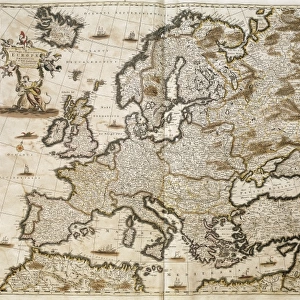
Metal Print : Moschoviae Tabula, map of Russia and European cities along the Volga River


![]()
Metal Prints From Fine Art Finder
Moschoviae Tabula, map of Russia and European cities along the Volga River
AIS5334417 Moschoviae Tabula, map of Russia and European cities along the Volga River, 1525 (colour manuscript) by Agnese, Battista (1514-64); Biblioteca Nazionale Marciana, Venice, Italy; (add.info.: Moschoviae Tabula, map of Russia and European cities along the Volga River. Considered as the oldest map of Russia. Colourful manuscript, 1525, by Battista Agnese (ca. 1500-1564) from the descriptions of Paolo Giovio (Paul Jove, 1483-1552). Biblioteca nazionale marciana, Venice (Italy).); eIberfoto; Italian, out of copyright
Media ID 22584922
© Iberfoto / Bridgeman Images
Atlas Book Of Maps Cinquecento Geographical Map
16"x20" (51x41cm) Metal Print
Discover the rich history of Russia and European cities along the Volga River with our stunning Metal Prints from Media Storehouse, featuring the intricately detailed Moschoviae Tabula map. This beautiful 1525 manuscript by Battista Agnese, housed in the Biblioteca Nazionale Marciana in Venice, showcases the geography of the region during the Renaissance era. Our high-quality Metal Prints bring the vibrant colors and intricate lines of this historic map to life, making it a captivating addition to any home or office decor. Experience the allure of the past with this unique and intriguing piece of fine art.
Made with durable metal and luxurious printing techniques, our metal photo prints go beyond traditional canvases, adding a cool, modern touch to your space. Wall mount on back. Eco-friendly 100% post-consumer recycled ChromaLuxe aluminum surface. The thickness of the print is 0.045". Featuring a Scratch-resistant surface and Rounded corners. Backing hangers are attached to the back of the print and float the print 1/2-inch off the wall when hung, the choice of hanger may vary depending on size and International orders will come with Float Mount hangers only. Finished with a brilliant white high gloss surface for unsurpassed detail and vibrance. Printed using Dye-Sublimation and for best care we recommend a non-ammonia glass cleaner, water, or isopropyl (rubbing) alcohol to prevent harming the print surface. We recommend using a clean, lint-free cloth to wipe off the print. The ultra-hard surface is scratch-resistant, waterproof and weatherproof. Avoid direct sunlight exposure.
Made with durable metal and luxurious printing techniques, metal prints bring images to life and add a modern touch to any space
Estimated Image Size (if not cropped) is 50.8cm x 40.6cm (20" x 16")
Estimated Product Size is 51.4cm x 41.2cm (20.2" x 16.2")
These are individually made so all sizes are approximate
Artwork printed orientated as per the preview above, with landscape (horizontal) orientation to match the source image.
FEATURES IN THESE COLLECTIONS
> Arts
> Artists
> A
> Battista Agnese
> Arts
> Landscape paintings
> Waterfall and river artworks
> River artworks
> Europe
> Italy
> Veneto
> Venice
> Europe
> Russia
> Related Images
> Maps and Charts
> Italy
EDITORS COMMENTS
This vibrant and intricate print captures the "Moschoviae Tabula" a map of Russia and European cities along the Volga River. Created in 1525 by Battista Agnese, this colourful manuscript is considered to be the oldest map of Russia. Housed in the Biblioteca Nazionale Marciana in Venice, Italy, it showcases Agnese's exceptional cartography skills. The map provides a fascinating glimpse into 16th-century geography, with detailed depictions of various Russian regions and European settlements along the iconic Volga River. From Moscow to Kazan, each city is meticulously illustrated with its own unique architectural features. Battista Agnese drew inspiration from Paolo Giovio's descriptions while creating this masterpiece. The result is an extraordinary blend of artistry and accuracy that transports viewers back in time to explore Russia during this pivotal era. With its rich colors and meticulous attention to detail, this print serves as both a historical artifact and a work of art. It offers us an opportunity to appreciate not only Agnese's talent but also his contribution to our understanding of early Russian geography. Whether you are fascinated by cartography or simply intrigued by history, this image will surely transport you on a visual journey through 16th-century Russia and its connection with Europe along the majestic Volga River.
MADE IN THE USA
Safe Shipping with 30 Day Money Back Guarantee
FREE PERSONALISATION*
We are proud to offer a range of customisation features including Personalised Captions, Color Filters and Picture Zoom Tools
SECURE PAYMENTS
We happily accept a wide range of payment options so you can pay for the things you need in the way that is most convenient for you
* Options may vary by product and licensing agreement. Zoomed Pictures can be adjusted in the Basket.