Metal Print > Europe > France > Canton > Landes
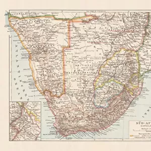
Metal Print : Map Of German South-West Africa At Beginning Of First World War. From The Great World War A History Volume Iii, Published 1916


![]()
Metal Prints from Design Pics
Map Of German South-West Africa At Beginning Of First World War. From The Great World War A History Volume Iii, Published 1916
Design Pics offers Distinctively Different Imagery representing over 1,500 contributors
Media ID 18190099
© Ken Welsh / Design Pics
Africa First German Great Land Namibia South South West West World Namaqua
16"x20" (51x41cm) Metal Print
Step back in time with our vintage Map of German South-West Africa at the beginning of the First World War, taken from The Great World War A History Volume III, published in 1916 by Ken Welsh. This captivating metal print brings history to life with its intricate details and authentic antique look. The map provides a fascinating insight into the geopolitical landscape of the time, making it a unique and thought-provoking addition to any home or office. Order now and let this historical piece tell a story that spans over a century.
Made with durable metal and luxurious printing techniques, our metal photo prints go beyond traditional canvases, adding a cool, modern touch to your space. Wall mount on back. Eco-friendly 100% post-consumer recycled ChromaLuxe aluminum surface. The thickness of the print is 0.045". Featuring a Scratch-resistant surface and Rounded corners. Backing hangers are attached to the back of the print and float the print 1/2-inch off the wall when hung, the choice of hanger may vary depending on size and International orders will come with Float Mount hangers only. Finished with a brilliant white high gloss surface for unsurpassed detail and vibrance. Printed using Dye-Sublimation and for best care we recommend a non-ammonia glass cleaner, water, or isopropyl (rubbing) alcohol to prevent harming the print surface. We recommend using a clean, lint-free cloth to wipe off the print. The ultra-hard surface is scratch-resistant, waterproof and weatherproof. Avoid direct sunlight exposure.
Made with durable metal and luxurious printing techniques, metal prints bring images to life and add a modern touch to any space
Estimated Image Size (if not cropped) is 40.6cm x 50.8cm (16" x 20")
Estimated Product Size is 41.2cm x 51.4cm (16.2" x 20.2")
These are individually made so all sizes are approximate
Artwork printed orientated as per the preview above, with portrait (vertical) orientation to match the source image.
FEATURES IN THESE COLLECTIONS
> Africa
> Namibia
> Related Images
> Africa
> South Africa
> Maps
> Africa
> South Africa
> Related Images
> Europe
> France
> Canton
> Landes
> Maps and Charts
> Related Images
> Maps and Charts
> World
EDITORS COMMENTS
This print showcases a historical map of German South-West Africa at the onset of the First World War. Published in 1916 as part of "The Great World War: A History Volume III" this illustration offers an intriguing glimpse into a pivotal moment in time. The map vividly depicts the vast expanse of land that encompasses Namibia, known then as German South-West Africa. With meticulous detail, every contour and boundary is meticulously outlined, allowing viewers to immerse themselves in the geography and topography of this region. From the arid plains of Namaqualand to the untamed wilderness stretching across Namibia, this map captures both the beauty and complexity of German South-West Africa. As we reflect on history's turning points, it becomes apparent that this particular map holds immense significance. It represents not only a geographical snapshot but also serves as a visual reminder of how global conflicts can shape nations and territories. Ken Welsh's expert craftsmanship brings life to this vintage piece, preserving its authenticity for generations to come. Whether you are an avid historian or simply captivated by cartography, this print invites you to explore an era when borders were redrawn and alliances tested amidst the chaos of war.
MADE IN THE USA
Safe Shipping with 30 Day Money Back Guarantee
FREE PERSONALISATION*
We are proud to offer a range of customisation features including Personalised Captions, Color Filters and Picture Zoom Tools
SECURE PAYMENTS
We happily accept a wide range of payment options so you can pay for the things you need in the way that is most convenient for you
* Options may vary by product and licensing agreement. Zoomed Pictures can be adjusted in the Cart.