Home > Europe > Republic of Ireland > Maps
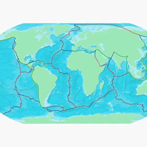
Structural geological units of Britain and Ireland

![]()
Wall Art and Photo Gifts from Mary Evans Picture Library
Structural geological units of Britain and Ireland
Map shows the main structural units of Britain, Ireland and surrounding seas. Fig 10 from Britain Before Man (1978), a Geological Museum publication
Mary Evans Picture Library makes available wonderful images created for people to enjoy over the centuries
Media ID 8618247
© Mary Evans Picture Library 2015 - https://copyrighthub.org/s0/hub1/creation/maryevans/MaryEvansPictureID/10706166
Before Geological Geology Great Britain Structural Unit Isle Of Man
FEATURES IN THESE COLLECTIONS
> Europe
> Republic of Ireland
> Maps
> Maps and Charts
> Geological Map
EDITORS COMMENTS
1. Title: Structural Geological Units of Britain and Ireland: A Vibrant Palette of Geological History Fig. 10, derived from the esteemed publication "Britain Before Man" (1978) by the Geological Museum, offers a captivating glimpse into the structural geology of Britain, Ireland, and the surrounding seas. This evocative map invites us to delve into the complex and intriguing world of geological formations that underpin these lands. The rich tapestry of colours on the map represents the diverse range of structural geological units that span the region. From the deep, dark blues of the oceanic crust to the vibrant reds and oranges of sedimentary rocks, each hue tells a story of the geological processes that have shaped the land over millions of years. The British Isles, including Great Britain, Ireland, and the Isle of Man, are depicted in intricate detail. The map reveals the complex interplay of various geological formations, from the ancient Precambrian basement rocks to the more recent sedimentary deposits. The intricate folding and faulting patterns, which have been influenced by tectonic forces, are clearly visible, offering valuable insights into the geological history of the region. The map extends beyond the shores of Britain and Ireland, showcasing the geological connections between these lands and the surrounding seas. The North Sea, Irish Sea, and the Atlantic Ocean are all represented, highlighting the importance of marine environments in shaping the geological landscape. This stunning representation of the structural geological units of Britain and Ireland is not only a testament to the rich geological heritage of the region but also a reminder of the intricate and fascinating processes that have shaped our planet. It serves as a valuable resource for researchers, educators, and anyone with a curiosity for the natural world.
MADE IN THE USA
Safe Shipping with 30 Day Money Back Guarantee
FREE PERSONALISATION*
We are proud to offer a range of customisation features including Personalised Captions, Color Filters and Picture Zoom Tools
SECURE PAYMENTS
We happily accept a wide range of payment options so you can pay for the things you need in the way that is most convenient for you
* Options may vary by product and licensing agreement. Zoomed Pictures can be adjusted in the Cart.