Home > North America > United States of America > Maps
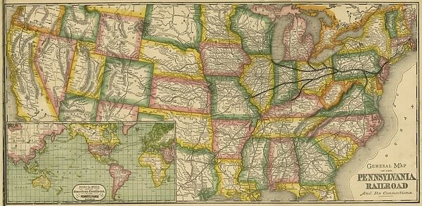
The Pennsylvania Railroad and its connections
![]()

Wall Art and Photo Gifts from Mary Evans Picture Library
The Pennsylvania Railroad and its connections
General map of the Pennsylvania Railroad and its connections
Mary Evans Picture Library makes available wonderful images created for people to enjoy over the centuries
Media ID 8834679
© Mary Evans Picture Library 2015 - https://copyrighthub.org/s0/hub1/creation/maryevans/MaryEvansPictureID/10699912
Connections Maps Pennsylvania Railroad
FEATURES IN THESE COLLECTIONS
> Mary Evans Prints Online
> Inst. of Mechanical Engineers
> North America
> United States of America
> Maps
> North America
> United States of America
> Pennsylvania
> Related Images
EDITORS COMMENTS
1. Title: "The Pennsylvania Railroad and Its Connections: A Comprehensive Map of America's Premier East Coast Railway Network" This map print showcases the expansive reach of the Pennsylvania Railroad (PRR) and its intricate web of connections across the United States during the late 19th century. The Pennsylvania Railroad, an American icon, was the largest railroad in the world at the time, spanning over 9,000 miles and connecting major cities from the East Coast to the Midwest. The map illustrates the railroad's primary lines, branch lines, and connections to other major railways, providing a visual representation of the PRR's integral role in the nation's transportation infrastructure. The map's intricate details reveal the railroad's extensive network, which included lines stretching from the Great Lakes to the Atlantic Ocean, and from the Ohio River to the Susquehanna River. The map also highlights the railroad's key terminals, including the iconic Pennsylvania Station in New York City, which served as the primary hub for PRR's passenger services. The map also reveals the railroad's connections to other major railways, such as the Baltimore and Ohio Railroad, the New York Central Railroad, and the Erie Railroad, among others. This map provides a fascinating glimpse into the history of rail transportation in America and the role that the Pennsylvania Railroad played in shaping the country's transportation landscape. The intricate details and vibrant colors bring the map to life, making it an essential addition to any collection of American history, transportation, or railway memorabilia. Whether you are a historian, rail enthusiast, or simply someone who appreciates the beauty and history of maps, this print is sure to captivate and inspire you. Hang it on your wall and let it transport you back in time to an era when the Pennsylvania Railroad reigned supreme as the backbone of America's transportation network.
MADE IN THE USA
Safe Shipping with 30 Day Money Back Guarantee
FREE PERSONALISATION*
We are proud to offer a range of customisation features including Personalised Captions, Color Filters and Picture Zoom Tools
SECURE PAYMENTS
We happily accept a wide range of payment options so you can pay for the things you need in the way that is most convenient for you
* Options may vary by product and licensing agreement. Zoomed Pictures can be adjusted in the Cart.


