Home > Oceania > Australia > Maps
Framed Print : Maps / Australia Post-1876


![]()
Framed Photos from Mary Evans Picture Library
Maps / Australia Post-1876
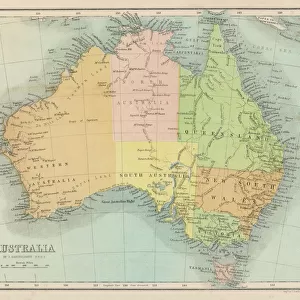
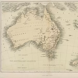
Map of Australia with names of Counties
Mary Evans Picture Library makes available wonderful images created for people to enjoy over the centuries
Media ID 608854
© Mary Evans Picture Library 2015 - https://copyrighthub.org/s0/hub1/creation/maryevans/MaryEvansPictureID/10114186
22"x18" Modern Frame
Discover the captivating history of Australia with our exquisite "Maps / Australia Post-1876" Framed Print from the Media Storehouse collection, brought to you by Mary Evans Picture Library via Mary Evans Prints Online. This stunning piece showcases an intricately detailed map of Australia as it appeared in 1876. Each county is clearly labeled, providing a fascinating insight into the geographical and historical landscape of the time. Our Framed Prints are meticulously crafted to preserve the rich detail and vibrant colors of the original image, ensuring that this piece becomes a captivating conversation starter in your home or office. Bring a touch of history and sophistication to your space with the "Maps / Australia Post-1876" Framed Print from Media Storehouse.
20x16 Print in an MDF Wooden Frame with 180 gsm Satin Finish Paper. Glazed using shatter proof thin plexiglass. Frame thickness is 1 inch and depth 0.75 inch. Fluted cardboard backing held with clips. Supplied ready to hang with sawtooth hanger and rubber bumpers. Spot clean with a damp cloth. Packaged foam wrapped in a card.
Contemporary Framed and Mounted Prints - Professionally Made and Ready to Hang
Estimated Image Size (if not cropped) is 50.8cm x 45.7cm (20" x 18")
Estimated Product Size is 55.9cm x 45.7cm (22" x 18")
These are individually made so all sizes are approximate
Artwork printed orientated as per the preview above, with landscape (horizontal) orientation to match the source image.
FEATURES IN THESE COLLECTIONS
> Maps and Charts
> Early Maps
EDITORS COMMENTS
This map print, titled "Map of Australia" from Mary Evans Picture Library, offers a glimpse into the rich historical geography of Australia during the late 19th century. Dated 1876, this map is an essential document in understanding the evolution of Australia's administrative divisions. The map is adorned with intricate detail, showcasing the vast expanse of the Australian continent with its diverse topography, from the lush green forests of Tasmania in the south to the arid deserts of the interior. The map's most striking feature, however, is the meticulous labeling of the counties that covered Australia at the time. The counties, named after explorers, indigenous leaders, and geographical features, reflect the European influence on the Australian landscape. The map includes counties such as "County of Cook," named after the famous British explorer, and "County of Barkly," named after Sir Thomas Baker Barkly, a prominent figure in the colonial administration. The map also highlights the various territories and colonies that made up Australia during this period, including Victoria, New South Wales, Queensland, South Australia, Tasmania, and Western Australia. The map's historical significance lies in its ability to provide a snapshot of Australia's administrative divisions during a time of significant growth and change. This map print is an invaluable resource for historians, genealogists, and anyone with an interest in the history of Australia. Its intricate detail and historical accuracy make it a fascinating addition to any collection, offering a unique perspective on the geography and history of this vast and diverse continent.
MADE IN THE USA
Safe Shipping with 30 Day Money Back Guarantee
FREE PERSONALISATION*
We are proud to offer a range of customisation features including Personalised Captions, Color Filters and Picture Zoom Tools
SECURE PAYMENTS
We happily accept a wide range of payment options so you can pay for the things you need in the way that is most convenient for you
* Options may vary by product and licensing agreement. Zoomed Pictures can be adjusted in the Cart.