Home > Europe > United Kingdom > England > Maps
Photographic Print : Map / Isle of Wight C1857


Photo Prints from Mary Evans Picture Library
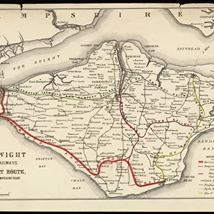
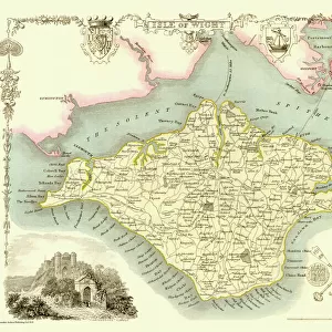
Map / Isle of Wight C1857
Map of the Isle of Wight (County series)
Mary Evans Picture Library makes available wonderful images created for people to enjoy over the centuries
Media ID 608796
© Mary Evans Picture Library 2015 - https://copyrighthub.org/s0/hub1/creation/maryevans/MaryEvansPictureID/10114004
14"x11" Photo Print
Discover the rich history of the Isle of Wight with our stunning photographic print from Mary Evans Picture Library. This captivating image, titled "Map / Isle of Wight C1857," offers a glimpse into the past with its intricately detailed antique map. Dating back to the late 19th century, this print showcases the County series map of the Isle of Wight, providing a fascinating look at the island's topography and geography during that time. Bring history into your home or office with this beautiful, high-quality print, perfect for enhancing any decor or inspiring wanderlust. Order yours today from Media Storehouse's extensive collection of Mary Evans Prints Online.
Photo prints are produced on Kodak professional photo paper resulting in timeless and breath-taking prints which are also ideal for framing. The colors produced are rich and vivid, with accurate blacks and pristine whites, resulting in prints that are truly timeless and magnificent. Whether you're looking to display your prints in your home, office, or gallery, our range of photographic prints are sure to impress. Dimensions refers to the size of the paper in inches.
Our Photo Prints are in a large range of sizes and are printed on Archival Quality Paper for excellent colour reproduction and longevity. They are ideal for framing (our Framed Prints use these) at a reasonable cost. Alternatives include cheaper Poster Prints and higher quality Fine Art Paper, the choice of which is largely dependant on your budget.
Estimated Product Size is 35.5cm x 27.9cm (14" x 11")
These are individually made so all sizes are approximate
Artwork printed orientated as per the preview above, with landscape (horizontal) or portrait (vertical) orientation to match the source image.
FEATURES IN THESE COLLECTIONS
> Europe
> United Kingdom
> England
> Isle of Wight
> Related Images
> Europe
> United Kingdom
> England
> Maps
> Maps and Charts
> Early Maps
> Popular Themes
> Maps and Charts
EDITORS COMMENTS
This stunning historical map print of the Isle of Wight from 1857 offers a fascinating glimpse into the past, showcasing the intricate details and boundaries of this beautiful English island. The intricate cartography captures the essence of a bygone era, allowing us to explore and appreciate the rich history and heritage of this iconic location.
The County series map is not just a geographical representation but also serves as a valuable historical document, shedding light on how the Isle of Wight was perceived and understood in the mid-19th century. It provides insight into land divisions, settlements, transportation routes, and other important features that shaped life on the island during that time.
As we study this map closely, we can imagine what life was like for residents living on the Isle of Wight over 150 years ago. The careful attention to detail and craftsmanship evident in this print remind us of the artistry involved in creating maps before modern technology made them more accessible.
Whether you have personal ties to this enchanting island or simply appreciate its natural beauty and cultural significance, this vintage map print is sure to captivate your imagination and inspire further exploration into its storied past. A true treasure for history buffs, cartography enthusiasts, or anyone with an appreciation for timeless artwork.
MADE IN THE USA
Safe Shipping with 30 Day Money Back Guarantee
FREE PERSONALISATION*
We are proud to offer a range of customisation features including Personalised Captions, Color Filters and Picture Zoom Tools
SECURE PAYMENTS
We happily accept a wide range of payment options so you can pay for the things you need in the way that is most convenient for you
* Options may vary by product and licensing agreement. Zoomed Pictures can be adjusted in the Cart.