Jigsaw Puzzle > Europe > United Kingdom > England > Maps
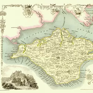
Jigsaw Puzzle : Map / Isle of Wight C1857


Jigsaw Puzzles from Mary Evans Picture Library
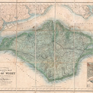
Map / Isle of Wight C1857
Map of the Isle of Wight (County series)
Mary Evans Picture Library makes available wonderful images created for people to enjoy over the centuries
Media ID 608796
© Mary Evans Picture Library 2015 - https://copyrighthub.org/s0/hub1/creation/maryevans/MaryEvansPictureID/10114004
Jigsaw Puzzle (520 Pieces)
Discover the captivating history of the Isle of Wight with our exquisite jigsaw puzzle from Media Storehouse, featuring the detailed and intriguing "Map / Isle of Wight C1857" by Mary Evans Picture Library. This beautiful puzzle, sourced from Mary Evans Prints Online, invites you on a journey back in time as you piece together this County series map from the year 1857. With the rich, authentic colors of the map and the intricate details of the coastlines, harbors, and towns, this puzzle is perfect for history enthusiasts, puzzle collectors, or anyone looking for a challenging and rewarding pastime. Immerse yourself in the charm of the Isle of Wight as you bring this captivating piece of history back to life, one puzzle piece at a time.
Made in the USA, 520-piece puzzles measure 16" x 20" (40.6 x 50.8 cm). Every puzzle is meticulously printed on glossy photo paper, which has a strong 1.33 mm thickness. Delivered in a black storage cardboard box, these puzzles are both stylish and practical. (Note: puzzles contain small parts and are not suitable for children under 3 years of age.)
Jigsaw Puzzles are an ideal gift for any occasion
Estimated Product Size is 50.8cm x 40.5cm (20" x 15.9")
These are individually made so all sizes are approximate
Artwork printed orientated as per the preview above, with landscape (horizontal) or portrait (vertical) orientation to match the source image.
FEATURES IN THESE COLLECTIONS
> Europe
> United Kingdom
> England
> Isle of Wight
> Related Images
> Europe
> United Kingdom
> England
> Maps
> Europe
> United Kingdom
> England
> Posters
> Europe
> United Kingdom
> England
> Related Images
> Maps and Charts
> Early Maps
> Maps and Charts
> Related Images
> Popular Themes
> Maps and Charts
EDITORS COMMENTS
This stunning historical map print of the Isle of Wight from 1857 offers a fascinating glimpse into the past, showcasing the intricate details and boundaries of this beautiful English island. The intricate cartography captures the essence of a bygone era, allowing us to explore and appreciate the rich history and heritage of this iconic location.
The County series map is not just a geographical representation but also serves as a valuable historical document, shedding light on how the Isle of Wight was perceived and understood in the mid-19th century. It provides insight into land divisions, settlements, transportation routes, and other important features that shaped life on the island during that time.
As we study this map closely, we can imagine what life was like for residents living on the Isle of Wight over 150 years ago. The careful attention to detail and craftsmanship evident in this print remind us of the artistry involved in creating maps before modern technology made them more accessible.
Whether you have personal ties to this enchanting island or simply appreciate its natural beauty and cultural significance, this vintage map print is sure to captivate your imagination and inspire further exploration into its storied past. A true treasure for history buffs, cartography enthusiasts, or anyone with an appreciation for timeless artwork.
MADE IN THE USA
Safe Shipping with 30 Day Money Back Guarantee
FREE PERSONALISATION*
We are proud to offer a range of customisation features including Personalised Captions, Color Filters and Picture Zoom Tools
SECURE PAYMENTS
We happily accept a wide range of payment options so you can pay for the things you need in the way that is most convenient for you
* Options may vary by product and licensing agreement. Zoomed Pictures can be adjusted in the Cart.