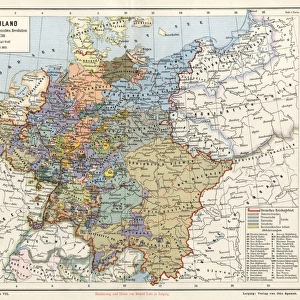
Photographic Print : Map / Europe C1840


![]()
Photo Prints from Mary Evans Picture Library
Map / Europe C1840
Map of Europe Date: circa 1840
Mary Evans Picture Library makes available wonderful images created for people to enjoy over the centuries
Media ID 7122001
© Mary Evans Picture Library 2015 - https://copyrighthub.org/s0/hub1/creation/maryevans/MaryEvansPictureID/10114203
14"x11" Photo Print
Discover the rich history of Europe with our exquisite and authentic Map / Europe C1840 print from Media Storehouse. Meticulously sourced from Mary Evans Prints Online, this beautifully detailed map transports you back in time to an era of exploration and discovery. With intricate cartography and vivid colors, this rights-managed photographic print is an essential addition to any history or geography enthusiast's collection. Bring the past to life in your home or office and add a touch of historical charm to your space.
Photo prints are produced on Kodak professional photo paper resulting in timeless and breath-taking prints which are also ideal for framing. The colors produced are rich and vivid, with accurate blacks and pristine whites, resulting in prints that are truly timeless and magnificent. Whether you're looking to display your prints in your home, office, or gallery, our range of photographic prints are sure to impress. Dimensions refers to the size of the paper in inches.
Our Photo Prints are in a large range of sizes and are printed on Archival Quality Paper for excellent colour reproduction and longevity. They are ideal for framing (our Framed Prints use these) at a reasonable cost. Alternatives include cheaper Poster Prints and higher quality Fine Art Paper, the choice of which is largely dependant on your budget.
Estimated Product Size is 35.5cm x 27.9cm (14" x 11")
These are individually made so all sizes are approximate
Artwork printed orientated as per the preview above, with landscape (horizontal) orientation to match the source image.
EDITORS COMMENTS
1. Title: "Exploring the Past: A Glimpse into Europe's Historical Landscapes through a 1840 Map" This antique map print, dated circa 1840, offers a fascinating glimpse into Europe's historical landscapes as they appeared over 170 years ago. The intricate details of this map, sourced from Mary Evans Prints Online, provide an invaluable record of the geographical knowledge and cartographic skills of the time. The map, titled "Europe," is adorned with borders depicting various European coats of arms, adding a touch of elegance and historical authenticity. The intricate cartography reveals the political divisions of Europe during the 19th century, with borders clearly delineating the territories of various European powers. The map also features annotations, including the names of major cities, rivers, and mountains, providing a wealth of information for those interested in European history and geography. The inclusion of detailed coastlines and topographical features further enhances the map's value as a historical document. As we explore this map, we are transported back in time to an era of exploration, discovery, and the expansion of European empires. The map serves as a testament to the advances in cartography and the growing European interest in mapping and understanding their world. This map print is not only an essential addition to any history or geography enthusiast's collection but also a beautiful piece of art that adds character and charm to any room. Its intricate details and historical significance make it a captivating conversation starter and a reminder of Europe's rich history. In conclusion, this 1840 map of Europe is more than just a geographical representation; it is a window into the past, offering a unique perspective on Europe's historical landscapes and the knowledge and skills of the cartographers of the time.
MADE IN THE USA
Safe Shipping with 30 Day Money Back Guarantee
FREE PERSONALISATION*
We are proud to offer a range of customisation features including Personalised Captions, Color Filters and Picture Zoom Tools
SECURE PAYMENTS
We happily accept a wide range of payment options so you can pay for the things you need in the way that is most convenient for you
* Options may vary by product and licensing agreement. Zoomed Pictures can be adjusted in the Cart.