Home > Asia > Thailand > Maps
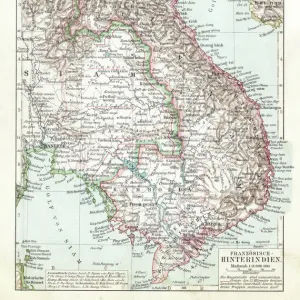
Canvas Print : Map Siam / Thailand 1893


![]()
Canvas Prints from Mary Evans Picture Library
Map Siam / Thailand 1893
Map showing the Kingdom of Siam, now Thailand
Mary Evans Picture Library makes available wonderful images created for people to enjoy over the centuries
Media ID 604251
© Mary Evans Picture Library 2015 - https://copyrighthub.org/s0/hub1/creation/maryevans/MaryEvansPictureID/10129090
20"x16" (51x41cm) Canvas Print
Introducing the captivating "Map Siam / Thailand 1893" Canvas Print from our Media Storehouse collection. This exquisite piece, sourced from Mary Evans Picture Library at Mary Evans Prints Online, transports you back in time with an intricately detailed map of the Kingdom of Siam, now Thailand, as it existed in 1893. The vintage cartography, rich in historical significance, is brought to life on high-quality canvas, creating a stunning and unique addition to your home or office decor. Immerse yourself in the stories of the past and add a touch of timeless charm to your space with this captivating canvas print.
Delivered stretched and ready to hang our premium quality canvas prints are made from a polyester/cotton blend canvas and stretched over a 1.25" (32mm) kiln dried knot free wood stretcher bar. Packaged in a plastic bag and secured to a cardboard insert for safe transit.
Canvas Prints add colour, depth and texture to any space. Professionally Stretched Canvas over a hidden Wooden Box Frame and Ready to Hang
Estimated Product Size is 40.6cm x 50.8cm (16" x 20")
These are individually made so all sizes are approximate
Artwork printed orientated as per the preview above, with portrait (vertical) orientation to match the source image.
FEATURES IN THESE COLLECTIONS
> Asia
> Related Images
> Asia
> Thailand
> Related Images
> Asia
> Turkmenistan
> Maps
> Maps and Charts
> Early Maps
> Maps and Charts
> Related Images
EDITORS COMMENTS
This antique map print, titled 'Map of Siam' and dated 1893, offers a fascinating glimpse into the historical geography of what is now modern-day Thailand. Published during the late 19th century, a period of significant political and territorial changes in Asia, this map showcases the Kingdom of Siam as it existed before its borders were redrawn by European colonial powers. The intricate details of the map reveal the rich cultural and geographical diversity of the region. The map is adorned with various topographical features, including mountains, rivers, and bodies of water, as well as major cities and towns. The strategic locations of important trade routes and ports are also clearly marked, reflecting the economic significance of maritime commerce during this era. The Kingdom of Siam, now known as Thailand, holds a unique place in Asian history as one of the few countries that managed to maintain its independence from European colonial rule. This map serves as a testament to the kingdom's resilience and sovereignty during a time when much of the continent was being carved up and colonized by European powers. The map's historical significance extends beyond the borders of Siam, as it also provides valuable context for understanding the broader political landscape of Asia during the late 19th century. The intricate details and meticulous accuracy of the map are a testament to the cartographic skills of the time and make this an invaluable resource for historians, geographers, and anyone with an interest in the history of Asia. This map print, with its rich historical context and intricate details, is a captivating addition to any collection of historical maps or Asian studies. Its antique charm and educational value make it a must-have for anyone seeking to deepen their understanding of the history and geography of Thailand and Asia as a whole.
MADE IN THE USA
Safe Shipping with 30 Day Money Back Guarantee
FREE PERSONALISATION*
We are proud to offer a range of customisation features including Personalised Captions, Color Filters and Picture Zoom Tools
SECURE PAYMENTS
We happily accept a wide range of payment options so you can pay for the things you need in the way that is most convenient for you
* Options may vary by product and licensing agreement. Zoomed Pictures can be adjusted in the Cart.