Home > Europe > United Kingdom > Scotland > Fife > St Andrews
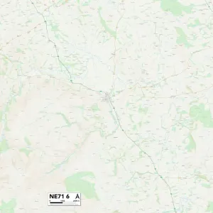
Gateshead NE42 6 Map

![]()
Wall Art and Photo Gifts from Map Marketing
Gateshead NE42 6 Map
Postcode Sector Map of Gateshead NE42 6
Media ID 19974630
Beaumont Way Burnside Close Castle Road Castle View Cherry Grove Coal Lane Cranbrook Drive Dene Close Dene Grove Dene View Dukes Court Dukes Way Earls Court Gateshead Hawthorn Gardens Highfield Highfield Lane Holly Grove Horsley Road Jubilee Road Lime Grove Main Road Maple Grove Milton Grove Piper Road Princess Court Princess Way Rowan Grove Springfield Springfield Close St Andrews Lane Station Road Sycamore Grove The Green West Road Western Avenue Wheatfield Close Windsor Crescent Ovingham Ovington Prudhoe
FEATURES IN THESE COLLECTIONS
> Animals
> Mammals
> Muridae
> Western Mouse
> Europe
> United Kingdom
> Scotland
> Fife
> St Andrews
> Map Marketing
> Postcode Sector Maps
> NE - Newcastle upon Tyne
> Map Marketing
> UK Maps
> Maps and Charts
> Related Images
MADE IN THE USA
Safe Shipping with 30 Day Money Back Guarantee
FREE PERSONALISATION*
We are proud to offer a range of customisation features including Personalised Captions, Color Filters and Picture Zoom Tools
SECURE PAYMENTS
We happily accept a wide range of payment options so you can pay for the things you need in the way that is most convenient for you
* Options may vary by product and licensing agreement. Zoomed Pictures can be adjusted in the Cart.