Home > Europe > United Kingdom > England > Derbyshire > Riddings
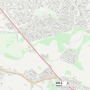
Derbyshire Dales S32 3 Map

![]()
Wall Art and Photo Gifts from Map Marketing
Derbyshire Dales S32 3 Map
Postcode Sector Map of Derbyshire Dales S32 3
Media ID 19980490
Baslow Road Brookfields Chapel Walk Cliff Lane Cornmill Close Cross Lane Derbyshire Dales Donkey Lane Dukes Drive Hazel Grove High Street Kingsgate Main Road Main Street Malthouse Lane Old Mill Lane Riddings Lane Riverside Close Riverside Court Riverside Drive The Green Calver Curbar
FEATURES IN THESE COLLECTIONS
> Animals
> Farm
> Donkeys
> Related Images
> Arts
> Portraits
> Pop art gallery
> Street art portraits
> Europe
> United Kingdom
> England
> Derbyshire
> Baslow
> Europe
> United Kingdom
> England
> Derbyshire
> Hassop
> Europe
> United Kingdom
> England
> Derbyshire
> High Peak
> Europe
> United Kingdom
> England
> Derbyshire
> Peak Dale
> Europe
> United Kingdom
> England
> Derbyshire
> Related Images
> Europe
> United Kingdom
> England
> Derbyshire
> Riddings
> Map Marketing
> Postcode Sector Maps
> S - Sheffield
> Map Marketing
> UK Maps
> Maps and Charts
> Related Images
MADE IN THE USA
Safe Shipping with 30 Day Money Back Guarantee
FREE PERSONALISATION*
We are proud to offer a range of customisation features including Personalised Captions, Color Filters and Picture Zoom Tools
SECURE PAYMENTS
We happily accept a wide range of payment options so you can pay for the things you need in the way that is most convenient for you
* Options may vary by product and licensing agreement. Zoomed Pictures can be adjusted in the Cart.