Home > Europe > United Kingdom > England > London > Boroughs > Wandsworth
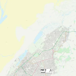
Wandsworth SW15 6 Map

![]()
Wall Art and Photo Gifts from Map Marketing
Wandsworth SW15 6 Map
Postcode Sector Map of Wandsworth SW15 6
Media ID 19982116
Balfour Place Balmoral Close Briar Walk Campion Road Cotman Close Dyers Lane Howards Lane Isis Close Nursery Close Parkfields St Johns Avenue St Margarets Crescent Tideswell Road Wandsworth Warwick Drive Woodborough Road Woodthorpe Road Putney Sw15
FEATURES IN THESE COLLECTIONS
> Animals
> Birds
> Passerines
> Wagtails And Pipits
> Related Images
> Arts
> Artists
> H
> John Hillers
> Arts
> Artists
> H
> John Hills
> Arts
> Artists
> L
> John Lodge
> Arts
> Artists
> L
> William Lodge
> Europe
> Italy
> Emilia-Romagna
> Ravenna
> Europe
> Italy
> Liguria
> Genoa
> Europe
> United Kingdom
> England
> London
> Boroughs
> Wandsworth
> Map Marketing
> Postcode Sector Maps
> SW - London SW
> Maps and Charts
> Related Images
MADE IN THE USA
Safe Shipping with 30 Day Money Back Guarantee
FREE PERSONALISATION*
We are proud to offer a range of customisation features including Personalised Captions, Color Filters and Picture Zoom Tools
SECURE PAYMENTS
We happily accept a wide range of payment options so you can pay for the things you need in the way that is most convenient for you
* Options may vary by product and licensing agreement. Zoomed Pictures can be adjusted in the Cart.