Home > Europe > United Kingdom > England > London > Boroughs > Croydon
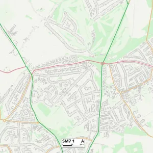
Reigate and Banstead SM7 3 Map

![]()
Wall Art and Photo Gifts from Map Marketing
Reigate and Banstead SM7 3 Map
Postcode Sector Map of Reigate and Banstead SM7 3
Media ID 19981714
Barn Close Beechfield Carshalton Road Court Hill Cunningham Road Farley Close Flint Close Grange Gardens Hatch Lane Heath Close Highfield Kenneth Road Longcroft Avenue Manor Way Orchard Close Park Road Pine Walk Rectory Lane Reigate And Banstead Salisbury Road South Drive Sutton Lane The Maples Cedars Woodmansterne
FEATURES IN THESE COLLECTIONS
> Animals
> Mammals
> Muridae
> Heath Mouse
> Arts
> Portraits
> Pop art gallery
> Street art portraits
> Europe
> United Kingdom
> England
> London
> Boroughs
> Croydon
> Europe
> United Kingdom
> Wales
> Flintshire
> Flint
> Map Marketing
> Postcode Sector Maps
> SM - Sutton
> Maps and Charts
> Related Images
MADE IN THE USA
Safe Shipping with 30 Day Money Back Guarantee
FREE PERSONALISATION*
We are proud to offer a range of customisation features including Personalised Captions, Color Filters and Picture Zoom Tools
SECURE PAYMENTS
We happily accept a wide range of payment options so you can pay for the things you need in the way that is most convenient for you
* Options may vary by product and licensing agreement. Zoomed Pictures can be adjusted in the Cart.