Home > Europe > United Kingdom > Scotland > Aberdeenshire > Alford
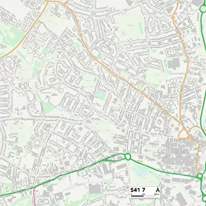
Chesterfield S40 1 Map

![]()
Wall Art and Photo Gifts from Map Marketing
Chesterfield S40 1 Map
Postcode Sector Map of Chesterfield S40 1
Media ID 19979008
Albion Road Alford Close Ash Tree Close Bank Street Bradbury Close Burlington Street Catherine Street Cavendish Street Charles Street Chester Street Chesterfield Church Lane Church Walk Church Way Clarence Road Clifton Street Elder Way High Street Hope Street Hunters Walk John Street Manor Crescent Manor Drive Manor Road Markham Road Marsden Street Melrose Close New Hall Road Old Hall Road Rockingham Close Rose Hill Rutland Road Shaftesbury Avenue South Place South Street Springfield Avenue St Marks Road St Marys Gate Stephenson Place Sydney Street Tennyson Avenue The Glade Vernon Road Vicar Lane Welwyn Close New Square Saltergate
FEATURES IN THESE COLLECTIONS
> Arts
> Artists
> B
> John Barker
> Arts
> Artists
> E
> John Elder
> Arts
> Artists
> H
> John Hillers
> Arts
> Artists
> H
> John Hills
> Arts
> Portraits
> Pop art gallery
> Street art portraits
> Europe
> United Kingdom
> England
> Rutland
> Related Images
> Europe
> United Kingdom
> Scotland
> Aberdeenshire
> Alford
> Europe
> United Kingdom
> Scotland
> Scottish Borders
> Melrose
> Map Marketing
> Postcode Sector Maps
> S - Sheffield
> Maps and Charts
> Related Images
MADE IN THE USA
Safe Shipping with 30 Day Money Back Guarantee
FREE PERSONALISATION*
We are proud to offer a range of customisation features including Personalised Captions, Color Filters and Picture Zoom Tools
SECURE PAYMENTS
We happily accept a wide range of payment options so you can pay for the things you need in the way that is most convenient for you
* Options may vary by product and licensing agreement. Zoomed Pictures can be adjusted in the Cart.