Home > Europe > United Kingdom > England > London > Politics > Edward Heath
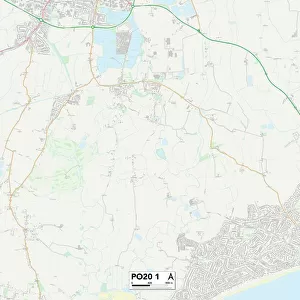
Tonbridge and Malling ME19 6 Map

![]()
Wall Art and Photo Gifts from Map Marketing
Tonbridge and Malling ME19 6 Map
Postcode Sector Map of Tonbridge and Malling ME19 6
Media ID 19974718
Addison Close Alma Road Ashton Way Beech Road Broadwater Road Chapel Street Church Fields Church Walk Columbine Close Columbine Road Elm Crescent Epsom Close Frog Lane High Street Howard Road Jasmine Close Jasmine Road King Street Larkspur Close Larkspur Road Lavender Close Lavender Road Lime Crescent Lister Close Meadow Bank Mill Street New Road New Town Norman Road Owen Close Rosemary Road Ruskin Close Sandown Road Shaftesbury Close St Leonards Street Station Road North Stratford Road Swan Street Temple Way The Grange The Heath Tonbridge And Malling Town Hill Tyler Close Walpole Close Water Lane Well Street West Street Woodland Close
FEATURES IN THESE COLLECTIONS
> Animals
> Amphibians
> Frogs
> North American True Frogs
> Green Frog
> Animals
> Mammals
> Muridae
> Heath Mouse
> Animals
> Mammals
> Muridae
> Water Mouse
> Arts
> Portraits
> Pop art gallery
> Street art portraits
> Europe
> United Kingdom
> England
> London
> Politics
> Edward Heath
> Map Marketing
> Postcode Sector Maps
> ME - Rochester
> Maps and Charts
> Related Images
MADE IN THE USA
Safe Shipping with 30 Day Money Back Guarantee
FREE PERSONALISATION*
We are proud to offer a range of customisation features including Personalised Captions, Color Filters and Picture Zoom Tools
SECURE PAYMENTS
We happily accept a wide range of payment options so you can pay for the things you need in the way that is most convenient for you
* Options may vary by product and licensing agreement. Zoomed Pictures can be adjusted in the Cart.