Home > Europe > United Kingdom > England > Rutland > Barrow
Reigate and Banstead RH1 1 Map

![]()
Wall Art and Photo Gifts from Map Marketing
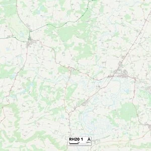
Reigate and Banstead RH1 1 Map
Postcode Sector Map of Reigate and Banstead RH1 1
Media ID 19979091
Carrington Close Chapel Road Churchill Close Clarendon Road Cromwell Road Fairfax Avenue Flint Close Furze Close Gloucester Road High Street Holland Close Huntingdon Road Keats Avenue Ladbroke Grove Lynwood Road North Street Oxford Road Princess Way Queensway Ravens Close Redhill Reigate And Banstead Reynolds Avenue Rutland Close Spruce Close St Annes Drive St Annes Way St Matthews Road Station Road Warwick Road
FEATURES IN THESE COLLECTIONS
> Arts
> Portraits
> Pop art gallery
> Street art portraits
> Europe
> United Kingdom
> England
> Rutland
> Barrow
> Europe
> United Kingdom
> England
> Rutland
> Related Images
> Europe
> United Kingdom
> Wales
> Flintshire
> Flint
> Map Marketing
> Postcode Sector Maps
> RH - Redhill
> Maps and Charts
> Related Images
MADE IN THE USA
Safe Shipping with 30 Day Money Back Guarantee
FREE PERSONALISATION*
We are proud to offer a range of customisation features including Personalised Captions, Color Filters and Picture Zoom Tools
SECURE PAYMENTS
We happily accept a wide range of payment options so you can pay for the things you need in the way that is most convenient for you
* Options may vary by product and licensing agreement. Zoomed Pictures can be adjusted in the Cart.